
This is the updated version of the winter outlook made on 12/10, with a few minor revisions. An updated winter outlook will be posted on January 1.
---------------------------------------------------
Winter 2011-2012 Final Outlook
NYC Area Weather
The winter of 2011-2012 got off to an unusually early start as a late October nor’easter brought widespread moderate to heavy snow across the area, with accumulations reported across almost the entire area over a month before the start of meteorological winter. Some places in the interior parts of the area already over a foot of snow. This early snowstorm did not keep the early winter conditions in place, however, as a much warmer pattern developed for November, with a persistent ridge in the eastern US bringing frequent surges of above to well above average temperatures into the region. The development of this pattern in November, which was not expected at first, caused me to change parts of my winter outlook, but even though we are currently in a mild pattern, this pattern will not prove to be the case for the entire winter.
A. Factors Behind The Forecast
1. La Niña Overview
There are three different ENSO states: La Niña, neutral, and El Niño. Sea surface temperature departures near the equator in the eastern Pacific are used to determine whether a La Niña or an El Niño is in place, with that specific region separated into four regions: ENSO regions 4 and 3.4 are to the west, with regions 3 and 1+2 further east. Below is a graphic from the CPC showing these regions:
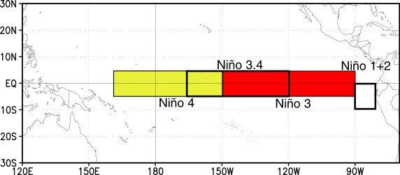
If ENSO region 3.4 averages at least 0.5 degree Celsius below normal for four consecutive months, there is a La Niña in place. If ENSO region 3.4 is at least 0.5 degree Celsius above normal, there is an El Niño in place. For this winter, we are dealing with a La Niña. Over this summer and fall, a La Niña developed again, making this winter a second consecutive La Niña, after last winter’s borderline strong La Niña. The La Niña is still developing and slightly weakened earlier this month, although it is intensifying again. I am expecting the La Niña to continue to intensify throughout the rest of this fall into the early winter with departures of at least -1.0 to -1.3 degrees Celsius, making this winter a moderate La Niña.
An average La Niña can result in a warmer than wetter than average winter in the Mid Atlantic, warmer and drier than average conditions in the South, and a colder and stormier than average northern US. Not every La Niña is the same, however, as the location of the coldest departures with the La Niña is important as well. Looking back at the graphic above showing the ENSO regions, the La Niña can either be east based, basin wide, or west based. If the coldest departures are focused in the western regions, the La Niña is west based; the opposite applies for an east based La Niña. A basin wide La Niña is observed when the coldest departures are spread throughout the ENSO regions. A west based La Niña, as we saw during the winter of 2007-2008, often results in a ridge near the East Coast with above average temperatures, with the colder departures focused towards the north central/NW US. An east based La Niña, as we saw during last year’s winter, often results in a colder and sometimes snowier than average winter for the East Coast. Currently, the La Niña is basin wide, fluctuating between slightly east and slightly west based, which can result in a scenario in between the two scenarios previously mentioned. At this time, I am expecting the La Niña to remain mainly basin wide throughout the winter.
2. Teleconnections
Some of the main teleconnections I used for this outlook will be defined and briefly discussed below. These teleconnections, as well as other variables such as the MJO, will be used throughout the rest of the outlook.
a. NAO

b. PNA

c. EPO

B. Pattern Outlook for This Winter
November Warmth: When making my fall outlooks, I anticipated a changeover to a colder pattern towards the second half of November, leading the way to a colder and snowier pattern for December. Instead, however, a very strong negative PNA pattern developed, combined with a persistent positive EPO. Despite the slightly negative NAO, the –PNA/+EPO pattern dominated the pattern across the US, resulting in a mild pattern for the central and eastern US with only transient cool spells lasting for 2-3 days at most. The colder departures this month have been focused over the western US, where troughs were more frequent, although these troughs didn’t bring any strong cold air into the US yet. The southeast ridge has been another part of this pattern, as a ridge has been stuck over the eastern US most of this month so far. A southeast ridge brings warmer than average temperatures into the East Coast closer to the coastal areas, and depending on its strength, occasionally into the rest of the Northeast and the Ohio Valley. Throughout November, a +EPO pattern has been dominant, along with a frequent ridge in the SE US, which brought well above average temperatures to the East.
Early-Mid December: During last year’s November, there were also above average temperatures just as there were this year except for the first week of the month and the Thanksgiving time frame, which was followed by a strong cold front on December 1st which started a sustained cold pattern that would last through late January with only a few breaks in between. This year, however, it will not be as easy to get this sustained cold as it was last year. During last November, there was already strong, sustained cold air over southern Canada, and with a very strong west based –NAO block, the cold air was able to pour into the eastern half of the United States along with a western US ridge. The current pattern, however, is far from ideal for a quick and strong pattern change. The +EPO/-PNA pattern has weakened, and the EPO is now slightly negative, with a neutral to slightly negative PNA. Despite the changes in the Pacific pattern, the Atlantic pattern remains unfavorable for cold, with a positive NAO and AO as well as a lack of blocking near Greenland. Last winter, the strong blocking, or a strong ridge west of Greenland, kept the cold pattern stuck in place. The current pattern features very little ridging near Greenland, and any ridge that does form near western Greenland remains transient and quickly moves out. Without the blocking, the cold will not be able to stay trapped over the region, and will remain mostly transient, and the lack of blocking also decreases the likelihood of snowstorms towards the coast, instead favoring interior areas for snowstorms. Although the ridge in the southeastern US weakens after December 8-9, the ridge fails to collapse, and troughs dropping into the north central US flatten out and weaken prior to reaching the East Coast. This pattern will keep near to slightly above average temperatures in the East for the first half of December, with the coldest departures focusing over the central US.
Rest of winter: La Niña years similar to the current one on average tend to bring slightly below average temperatures in December, lasting into January in some cases, with above average temperatures in February. This fall, however, has failed to follow the analog years so far with a much warmer than average November, and December is on track to bring above average temperatures again. The pattern so far consists of a positive NAO, positive AO and a negative PNA, usually found with typical La Ninas. Last year's La Nina was unusual as it contained a very strong -NAO/-AO block, a scenario rarely observed with strong La Ninas. Although some outlooks show the NAO and AO becoming negative by mid December, there is no sign of any large scale change in the pattern in Canada, with troughs still frequent near Greenland and no significant warming in the stratosphere, which a warming stratosphere would increase the chances of a -AO and a colder pattern in the US. As a result, the positive NAO and AO are likely to continue through most of December and potentially into parts of January. Meanwhile, the EPO is likely to return back towards positive, along with a -PNA, which brings the potential for a warmer second half of December. Overall, although occasional cold spells will take place in December, with a few Northeast snowstorms if the timing of storms ends up supportive, the colder departures are expected to focus over the central and western US, with a warmer than average East.
Through the first half of January, any large scale change in the pattern may be possible but does not seem very likely yet, with a +AO and a cold stratosphere likely to continue. Meanwhile, the MJO is modeled to end up near phase 5, unsupportive of East cold. By the second half of January, the potential may be there for the AO to trend more towards negative, and considering that the current pattern is locked in place and will take time to break, if a pattern change happens towards more cold and snow in the East, it may be focused more towards mid January. Although some cold and snow will take place until that point, the overall pattern up until that point is likely to consist of near-above average temperatures with below average snow for the northern Mid Atlantic, with a few transient periods of cold prior to early-mid January. These periods of transient cold will bring most of the snow potentials to the Northeast, but if the location of the storms is supportive, especially towards the very end of December into early January, the potential may be there for a few Mid Atlantic snow events, although these are more unlikely under this pattern. The second half of the winter, especially starting around early or mid January and into February, appears more likely to produce a colder and snowier pattern for the East, but with a lack of strong blocking and a strong -NAO/-AO as last winter featured, the best chance for above average snowfall will likely be focused from the Great Lakes towards the Northeast, and although snow events are expected in the northern Mid Atlantic, these storms would be more likely to include mixing with sleet and rain than the last two winters.
C. Monthly outlook for the northern Mid Atlantic
A colder start to December is expected for the region with a ridge in the western US which displaces the polar vortex over Alaska, likely focusing colder temperatures over the central and eastern US around the December 8-18 time frame. There is still a lack of blocking, and with ridging staying off the East Coast but not well offshore, most of the snowstorms will stay inland towards the Ohio Valley, Great Lakes and potentially the Northeast. Although the possibility of at least one snow event closer to I-95 cannot be ruled out later in the time frame, this pattern does not support I-95 snow events. The lack of blocking and a –NAO/-AO will also mean that the cold will not be able to remain stuck over the region for the entire first half of December, but even though occasional moderation in the cold pattern is expected, any warm spells will not be as strong as those of November.
Towards the second half of December, especially after December 15-20, it appears that the pattern may moderate again. There are some hints on the longer range models that a polar vortex may return into Alaska, which as we observed late this month, is not supportive of cold in the East. Along with a +NAO/+AO pattern, a rising EPO and a moderating –PNA, warmer departures are possible for the second half of the month, and the possibility is there for at least one significant warm spell in the second half of December. Occasional cold spells are still expected, which may produce snow for parts of the Northeast if the timing is supportive, although warm spells may become more frequent by that time. The forecast for December was a bit tough as the current pattern supports above average temperatures, but climatology from analog years with conditions similar to those of this year support a colder than average December. November’s analogs also supported a colder than average month yet temperatures ended up well above average, and for December, I’m siding closer to the pattern than the analogs, with slightly above to above average temperatures, slightly above average precipitation and below average snowfall across the northern Mid Atlantic.
NAO: Slightly positive
AO: Positive
PNA: Slightly negative

If a pattern change does take place where the East transitions to a more sustained period of cold and snow, January appears to be the more likely time frame for this to happen. The pattern for January and February is more uncertain and will be discussed in more details in separate monthly outlooks issued as these months get closer, but it appears at this time that early January may continue the overall above average temperature potential, with transient cold spells in between. Towards the second half of January, however, the NAO and AO may turn more towards neutral or slightly negative, and the potential may be there for a more winter pattern to affect the eastern US towards mid to late January compared to December and potentially early January. When such a colder pattern sets up for the East is not certain yet, and could range from late December to late January, although at this time, I am siding with the middle of January for the change towards a more winter-like pattern. The temperature departures are more uncertain, as the time frame that the pattern becomes colder, if it does so, would mean either colder or warmer than average departures depending on whether any change happens early or late in the month. With strong cold air available in Canada, however, when and if a colder pattern develops for January, stronger cold spells and more frequent snowstorms may be possible into the central and eastern US. Overall, I am expecting the month’s temperature to average out near to potentially slightly below average across the region with near average precipitation and average to potentially slightly above average snowfall. The time frame of the pattern change potential is still uncertain, however, and it is possible that January may turn out to be colder and snowier than currently expected.
NAO: Neutral
AO: Neutral
PNA: Neutral to slightly negative
February is more uncertain due to the time range, but the possibility is there for more of a –NAO and a -AO signal than the first half of the winter. The pattern may continue to favor the Northeast and the Great Lakes regions for the best potentials for snow, although the potential may be there for stronger and more frequent cold in the region with more frequent snow chances as well, although unlike the last two years, snow events would be more likely to mix with sleet and rain due to the lack of extreme –NAO/-AO blocking observed last year which kept almost every storm to the south of NYC. February’s outlook will be discussed in more details in January, although at this time, I am thinking that February may bring slightly below average temperatures with slightly above average precipitation and near to slightly above average snow.
NAO: Slightly negative
AO: Slightly negative
PNA: Neutral to slightly negative
Experimental Monthly Forecast for I-95 cities
New York City
December: +2 to +3 degrees
January: -1 to +1 degrees
February: -2 to 0 degrees
Overall: 0 to +2 degrees
Snowfall: 17-27 inches (Average: 26 inches)
Philadelphia, PA
December: +2 to +3 degrees
January: -1 to +1 degrees
February: -2 to 0 degrees
Overall: 0 to +2 degrees
Snowfall: 9-18 inches (Average: 19 inches)
Washington DC
December: +2 to +3 degrees
January: -1 to +1 degrees
February: -1 to +1 degrees
Overall: +1 to +3 degrees
Snowfall: 5-13 inches (Average: 16 inches)
D. Outlook for the United States
In summary, this winter is expected to be less extreme than last winter in the Mid Atlantic and southern Northeast regions, with increased snow towards the Great Lakes and Northeastern US. Although there will be snow events in the Mid Atlantic with a few coastal snowstorms possible, overall snow is expected to remain below average, with near average snowfall in the northern Mid Atlantic and slightly above average snow in southern New England. Snow forecasts are more risky, however, since only one big storm could bring areas easily towards their average snowfall, and if another big snowstorm affects the I-95 corridor this winter, snow amounts would likely be higher than shown above for the DC-NYC corridor. The first half of the winter will likely be warmer than average for parts of the East Coast with colder departures for the central and western US, with the second half of the winter potentially bringing more cold and snow to the East and colder temperatures into the central and eastern US.
Temperature outlook:


Snow outlook:

Areas of uncertainty: Long range forecasts are more risky than short to medium range forecasts, and as a result, there are several areas of uncertainty with the outlook. Although I labeled the East up to NYC with slightly above average temperatures, this is considering that a somewhat colder pattern with slightly below average temperatures affects the eastern US towards the second half of the winter. It is possible that a colder pattern fails to establish itself, in which case temperatures would end up above average across the entire East Coast. Pattern changes can come quick and strong, changing quickly from above to below average temperatures, and the possibility is there that after the first half of the winter, a much colder pattern could set up for the East, resulting in overall slightly below average temperatures for the Mid Atlantic and Northeast. The uncertain parts of the forecast include the snowfall outlook for the Mid Atlantic, temperatures for the East, and precipitation near the west coast. An update to this outlook will be posted in early January, discussing any changes in the outlook.
I live on Long Island. So far, the weather here has been pretty consistent with the outlook. November and December have been rainy and mild, with some colder drier days mixed in, but only to return to mild and wet. Generally speaking, I'd say temperatures have been slightly to moderately above average with above average precipitation (rain). I agree that at some point during January there will likely be a turn around with significantly colder temperatures lasting until at least late February. I expect there to be some snowfall from mid January until early March, but not nearly as much as the past couple of winters.
ReplyDelete