
Monday, October 31, 2011
Oct 31, 2011 Brief Update
Notes:
- Brief updates will continue through Wednesday or Thursday. By Thursday or Friday at the latest, regular daily discussions will be resumed.
- My November outlook will be posted in the Long Range Forecasts page tomorrow, discussing the warm up for the first half of this month and what may come for the second half of the month.
------------------------------------------------------
Brief Forecast Update:
- A weak coastal low pressure will stay mainly offshore tomorrow, possibly scraping parts of the area with light rain. With the cold air mass retreating by this time, no snow will fall out of this storm. Otherwise, mostly cloudy skies are expected with high temperatures peaking in the mid 50s across most of the area.
- Wednesday and Thursday will bring mainly sunny skies with temperatures slightly warming up into the upper 50s across most of the area. Parts of the NYC area are likely to reach the lower 60s on Thursday, breaking the 60 degree mark for the first time since last Wednesday.
- Another low pressure will approach the region for Friday. Currently, the models keep this storm to the south of the area, but the potential is there for this storm to trend stronger and bring more widespread rain for the area on Friday and potentially into early Saturday. No heavy rain is expected, however. Temperatures will cool back down towards the mid 50s.
- Behind this potential storm, a strong high pressure will move in for the weekend, most likely bringing sunny skies for the second half of Saturday into Sunday. High temperatures will gradually warm up into the upper 50s to mid 60s by Sunday, with cold overnight lows, likely dropping into the mid 20s to lower 30s north and west of NYC.
Tomorrow's update will discuss the outlook for this week/weekend, as well as next week and the longer range, in more details.
Sunday, October 30, 2011
Oct 30, 2011 Noon Update
After the storm left the region last night, today brought mostly sunny skies but with unusually cold high temperatures as the region begins to recover from the historic snowstorm, now holding the title of the biggest October snowstorm on record in parts of the region, and bringing snow totals to almost a quarter of the total winter average over a month before winter officially begins. Dry weather will help the clean up over the next few days, with moderating temperatures expected as well.
Yesterday's storm, although not as impressive in structure as modeled at first, will go down in history as the biggest October snowstorm for the immediate NYC area, with 2.9 inches in Central Park shattering the previous October record snowfall of 0.8 inch in 1925, and bringing totals as high as 6-12 inches even in the immediate north/west suburbs of NYC. Overall, this storm ended up bringing anywhere from 6 to as much as 16-19 inches of snow in NW NJ and Orange county in NY, 4 to 10 inches of snow in the north/west suburbs of NYC, 4 to 12 inches across most of southern CT (except for New London county with lower amounts), and up to 4 inches in Long Island, especially in Nassau county. The highest amounts across the area were 19 inches in West Milford, NJ, 17.2 inches in Danbury, CT, and 16 inches in Harriman, NY.
A complete summary of this storm will likely be posted sometime late this week, including a storm total snow map, a review of the storm's forecasting difficulties, the storm's development/impact on the region, and the historical impact of this storm.
-------------------------------------------------
Short Forecast Update: Brief updates will likely be posted for the next few days, with the regular daily updates to be resumed sometime later this week. Halloween will bring mostly sunny skies with high temperatures in the upper 40s to lower 50s across most of the area. Tuesday will bring similar temperatures with a weak coastal low staying mainly offshore, possibly bringing a risk of light rain to the eastern parts of the area. By Wednesday, the cold will weaken as temperatures warm back up well into the 50s and possibly nearing 60 degrees, staying there for the rest of this week. Tomorrow's update will discuss this week's outlook in more details.
Saturday, October 29, 2011
Oct 29-30, 2011 Snowstorm Updates
**If I lose power out of this storm, this blog will not be updated until power returns, which may take a few days.**
---------------------------------------------------------
10:35 PM: Snow Intensifies East of NYC, Ends Further West

The deformation band began making its way further east shortly after the last update was posted, and has now cleared all places to the west of NYC, where only light snow showers are currently falling and will end by 12 AM. The western edge of the heavy snow is currently over NYC into Westchester county and western CT, and continues to move further east. Moderate to locally heavy snow will fall across Long Island and southern Connecticut over the next 2-3 hours as the band continues to move further east slowly, ending from west to east. Additional light accumulations are expected with this band of snow, with NYC and Long Island likely seeing up to another inch, locally up to 2 inches, with southern CT likely seeing 1 to 2 inches. The heavier snow will end across the area between 12-2 AM.
---------------------------------------------------------
7:55 PM: Snow To Spread East Again

---------------------------------------------------------
6:05 PM: Snow Calms Down, But Will Intensify Soon
 According to the latest snow totals from the NWS, snow totals have exceeded 3-4 inches in most areas to the west and NW of NYC, with the highest report so far showing 9 inches in West Passaic county as of 3:30 PM, and since then, amounts most likely exceeded 10 inches in parts of NW NJ. Earlier this afternoon, with slightly over 1 inch of snow, Central Park broke the record for the snowiest October on record; the previous record was held by 1925 with 0.8 inch.
---------------------------------------------------------
4:30 PM: Heavy Snow Continues; Records Broken Across Area

A short break in the precipitation is approaching NYC and western Long Island as the deformation band, currently over Pennsylvania and western New Jersey, will continue to gradually move east. Parts of eastern NE NJ and southern Westchester counties may mix with and/or change over to light sleet/rain for a short period of time. The deformation band will then move into all of northern NJ and SE NY by at least 6 PM today, which will bring heavy snow to these areas again, and as the storm continues to move east, the deformation band will spread east, reaching the rest of the immediate NYC area this evening, with places currently seeing rain/sleet mixing with and changing over to snow. Another several hours of heavy snow are expected, followed by the snow tapering off around 12 AM from NYC and further west. Long Island and southern CT will continue to see heavy rain and strong winds for the short term, with snow mixing in by the evening and early overnight hours. Additional light accumulations are possible.
This is a VERY dangerous storm, and must not be taken lightly. The heavy wet snow will bring down trees and power lines, and power outages are possible for days. At this time, my updated forecast is for a storm total of 8 to 15 inches of snow in NW NJ/Orange county, 7 to 13 inches in the rest of NE NJ and SE NY, 2 to 5 inches in NYC, 1 to 4 inches in Long Island and 4 to 10 inches in southern CT. I will continue to post updates on this historic October snowstorm as long as I still have internet connection.
---------------------------------------------------------
12:10 PM: Heavy Snow Starts To Accumulate

The coastal low is still off the Mid Atlantic coast, and will continue to intensify while moving up the coast. While it may appear that the storm is quickly moving out, the intensifying low pressure will keep precipitation in place for a longer period of time. Once the low is near new Jersey's latitude, a deformation band of heavy snow will form over eastern Pennsylvania and New Jersey, extending the duration of the heavy snow while bringing the potential for thundersnow. After 3-4 PM, heavy snow will be the main precipitation type in northern NJ and SE NY, with a rain/snow mix in NYC and southern CT and heavy rain/thunderstorms in Long Island. The snow will continue to fall through the early overnight hours, ending by 12-3 AM across the area. With the heavier precipitation already staying over the area, it is possible that accumulations may have to be adjusted a little upwards in the immediate NYC area with the next update depending on how far north the warmth advances before colder temperatures move in and stick around for the night.
---------------------------------------------------------
10:55 AM: Snow Approaches; Slightly Increased Snow Forecast

The coastal low is currently near eastern Virginia, and is intensifying quickly while moving to the NNE. The intensifying low will result in heavier precipitation developing in the Mid Atlantic, moving towards the area by this afternoon, and the storm will pull the colder air towards the low pressure, changing over areas further east to snow. By at least 2-3 PM today, western NJ and Orange county will see heavy snow, while the north/west suburbs of NYC begin to mix with snow. With the heavier rain in the Mid Atlantic moving into the colder air mass over the area, heavy snow bands will begin to develop over northern New Jersey and eastern PA late this afternoon, and with the intensifying low pressure, thundersnow is even possible in parts of the area. The rain/snow line will gradually move further east, with the north/west suburbs of NYC changing over to a heavy wet snow betwen 3-6 PM, with the changeover closer to 6 PM for areas closest to NYC. Meanwhile, heavy rain will fall in Long Island and southern CT, with thunderstorms possible and winds gusting up to 50-60 mph.
By this evening, New York City will also change over from rain to a heavy, wind-driven wet snow, with southern Connecticut also changing over to snow and parts of Long Island starting to mix with snow. The snow will have difficulty accumulating at first in NYC due to the wet ground and warm ground temperatures, but with at least a 6 hour period of moderate to heavy wet snow expected, some accumulations are expected, and NYC will see at least up to 1 inch of snow, with parts of the city potentially reaching 2 inches. If these accumulations verify, this will be the snowiest October in Central Park's recorded history. The snow will end west of NYC by 12-1 AM, and east of NYC around 1-4 AM.

Stay tuned for more storm update throughout the day on this storm.
Friday, October 28, 2011
Oct 28, 2011: Significant Snowstorm Tomorrow
Behind a wave of low pressure that brought light rain to the area and light snow across the Northeast with light accumulations, today brought mostly sunny skies across the area with chilly high temperatures, peaking in the upper 40s to lower 50s across the area, colder than the average for this time of the year. Temperatures are currently holding steady across most of the area, slightly dropping in some places, as clouds move in from the southwest. A weak area of low pressure is currently bringing areas of light rain to the southern Mid Atlantic with accumulating snow observed in the mountains of West Virginia and western Maryland. A set up highly unusual for October will bring a stronger coastal low pressure up the coast, however, which will result in an unusually early snowstorm affecting the region with significant snow accumulations, even in parts of the NYC area.
Final Storm Discussion:
Following the model guidance for this storm was a challenge. From when the storm first appeared early this week, the model guidance quickly trended offshore for two days, and the only models that held onto the storm were the ECMWF and the UKMET models. While it appeared that these models would trend east to join the model agreement, the other models trended west significantly yesterday morning, showing a significant snowstorm for the NYC area. Today's models trended west once again, but there is now a split between the eastern and the western models.
The main concerns at this time regarding snow potential in the immediate NYC area and closer to the coast include the intensity of the storm, as the models have been trending slightly weaker with the storm. As I will discuss in the scenario section, the main reason we are seeing this snow potential and not just a rainstorm is because of the dynamics of the storm, including a rapidly intensifying low pressure pulling in cold air close to the storm center and heavy precipitation allowing for a heavy wet snow to fall. A weaker storm will result in weaker dynamics, and thus a warmer storm producing more rain and less snow for the immediate NYC area. This weakening trend, however, likely won't lead to any significantly lower snow accumulations if it continues, as a significant snowstorm is still expected for interior areas. The other issue is with the location of the storm, as the models are currently split into two camps; the first set of models, the GFS, CMC and the SREF, are showing a further west storm, bringing more rain and less snow across the area. The other models, the UKMET, ECMWF and the NAM, are siding with a colder and further east scenario, where NYC sees some rain changing over to heavy wet snow, with significant accumulations as far southeast as the immediate north/west suburbs of NYC. Currently, I sided with a solution in between, as the NAM may be too cold, but the GFS may be too warm as well, and the latest SREF run backed slightly to the east.
 Storm Scenario: This scenario is highly unusual for October, and something that we would typically see in December. For early and late season snowstorms to happen, everything has to end up just right, and in this case, all of the right ingredients are in place. There is a high pressure to the north, although it weakens slightly and moves to the north. There is a cold air mass in place before the storm, and as the storm intensifies, it will create its own cold air and pull the cold air towards the coast, which combined with a track off the coast and heavy precipitation, will produce snow in places where snow rarely falls in October. At first, the low pressure will still be weak tomorrow morning and afternoon, likely around 1006 mb, but by the afternoon and evening hours, the low pressure will intensify faster and move towards the NJ coast while heavy precipitation develops in the southern Mid Atlantic and moves north, reaching Pennsylvania and NJ by the afternoon. The low pressure will then continue to intensify, deepening to at least 992 mb by Saturday night while moving close to our just southeast of Cape Cod.
 Forecast for the NYC Area: Light precipitation is expected to develop in the area late tonight, with light rain from NYC and further east and a light rain/snow mix inland. By the morning, light snow will fall towards NW NJ/SE NY, with light rain elsewhere. Temperatures will peak early in the day from NYC and further west, reaching the mid 30s inland and the lower 40s across most of the immediate NYC area, getting warmer further east. As precipitation intensifies, temperatures will drop across the western half of the area. By at least 2 PM, moderate to locally heavy snow is expected to fall in Sussex/Orange counties, with a rain/snow mix in the north/west suburbs of NYC and rain, locally heavy, from NYC and further east.
As cold air continues to be pulled into the storm, temperatures aloft will cool down by the late afternoon and evening hours, and by at least 6-7 PM, most of northern New Jersey and SE NY are expected to change over to a heavy wet snow, while NYC sees a rain/snow mix and Long Island continues to see heavy rain with increasing winds, gusting up to 50-60 mph. The snow will have issues accumulating at first, especially due to the warm ground and wet conditions after the rain that falls earlier, but with the snow expected to fall heavily, it will eventually stick and begin to accumulate. A period of at least 6 hours of moderate to heavy snow is expected for the immediate north/west suburbs of NYC and southern CT, which will result in light to moderate snow accumulations in these areas, and with the mix changing over to a wet snow in NYC by the early overnight hours, light accumulations are very possible in NYC itself as well. Southern CT will change over to heavy snow by the early overnight hours, around the same time that parts of Long Island will mix with wet snow. As the storm moves east, snow will end from west to east, around 12-2 AM from NYC and further west, and 1-3 AM east of NYC.
 Snow Accumulations: Although the region has seen these snow amounts many times, this storm is historic considering the time of the year; Central Park only had accumulating October snowfall in three occasions since records were kept in the late 1860s. As long as there is no sudden change in the outcome, this will most likely be the 4th occasion, and if Central Park sees near or over 1 inch of snow, which is an increasingly likely scenario given the recent trends, this has the potential to be the snowiest October for NYC in recorded history. The last significant October snowstorms affected the area in October 2008 and 2009; these storms, however, only brought elevation dependent moderate to locally heavy accumulations in NW NJ, and no flakes fell in NYC.
At this time, considering the potential weakening trend of the storm, I went with a solution closer to the eastern models, with the heaviest snow likely falling from NE PA/NW NJ into interior SE NY, NW CT, western Massachusetts, and into southern New Hampshire and parts of southern Maine away from the coast. In this corridor, most areas should see over 7 inches of snow, and the potential may be there for up to a foot of wet snow in some areas. I went with slightly lower snow totals than shown by some models as the slightly weaker storm I am anticipating may lead to slightly less snowfall further west, but if the snowier case scenario verifies, the 7+ inch zone may be larger, extending more to the northwest, more towards the SW into central PA, and slightly more to the SE. A slightly weaker storm, however, will bring a smaller 7+ inch zone.
In the immediate NYC area, up to 1 inch of snow is expected for most of Long Island, with most places likely seeing a trace. In NYC, up to 1 inch of snow is expected, but in the colder case scenario, up to 2 inches may be possible in parts of the city. A sharp gradient is then likely to the north and west of NYC; the immediate north/west suburbs along with southern CT will likely see 2 to 4 inches of snow; further inland towards western Rockland and western Bergen are expected to see 4 to 7 inches of snow, and in NW NJ and interior SE NY, 6 to 10 inches of snow are expected, with amounts potentially up to 12 inches in isolated areas.
As I previously mentioned, a slightly weaker and further east storm may be possible for the area. This is only a recent trend on the models, and with the storm less than a day away, my focus during tomorrow's storm updates will be on current observations and short range models, to determine if a further east and weaker storm is more likely. If this is the result, the snow may not be as heavy in the area, but accumulations may still slightly increase, bringing 1-2 inches in parts of NYC and 3 to 5 inches in the immediate north/west suburbs and southern CT. A weaker storm, however, would mean that places in the interior Northeast would see less snow than expected, and some of the winter storm warnings may be downgraded to winter weather advisories. This is still only a potential, however, and it is very possible as well that the storm does not end up weaker than currently expected and follows the current forecast.
Regardless of how much snow falls, this will be a dangerous storm, bringing heavy wet snow capable of downing trees and resulting in widespread power outages. For coastal areas, strong winds are expected, gusting up to 50-60 mph in parts of Long Island, combined with heavy rain of up to 1-2 inches. Stay tuned for storm updates throughout the day tomorrow on this historic late October snowstorm.
Final Storm Discussion:
Following the model guidance for this storm was a challenge. From when the storm first appeared early this week, the model guidance quickly trended offshore for two days, and the only models that held onto the storm were the ECMWF and the UKMET models. While it appeared that these models would trend east to join the model agreement, the other models trended west significantly yesterday morning, showing a significant snowstorm for the NYC area. Today's models trended west once again, but there is now a split between the eastern and the western models.
The main concerns at this time regarding snow potential in the immediate NYC area and closer to the coast include the intensity of the storm, as the models have been trending slightly weaker with the storm. As I will discuss in the scenario section, the main reason we are seeing this snow potential and not just a rainstorm is because of the dynamics of the storm, including a rapidly intensifying low pressure pulling in cold air close to the storm center and heavy precipitation allowing for a heavy wet snow to fall. A weaker storm will result in weaker dynamics, and thus a warmer storm producing more rain and less snow for the immediate NYC area. This weakening trend, however, likely won't lead to any significantly lower snow accumulations if it continues, as a significant snowstorm is still expected for interior areas. The other issue is with the location of the storm, as the models are currently split into two camps; the first set of models, the GFS, CMC and the SREF, are showing a further west storm, bringing more rain and less snow across the area. The other models, the UKMET, ECMWF and the NAM, are siding with a colder and further east scenario, where NYC sees some rain changing over to heavy wet snow, with significant accumulations as far southeast as the immediate north/west suburbs of NYC. Currently, I sided with a solution in between, as the NAM may be too cold, but the GFS may be too warm as well, and the latest SREF run backed slightly to the east.


As cold air continues to be pulled into the storm, temperatures aloft will cool down by the late afternoon and evening hours, and by at least 6-7 PM, most of northern New Jersey and SE NY are expected to change over to a heavy wet snow, while NYC sees a rain/snow mix and Long Island continues to see heavy rain with increasing winds, gusting up to 50-60 mph. The snow will have issues accumulating at first, especially due to the warm ground and wet conditions after the rain that falls earlier, but with the snow expected to fall heavily, it will eventually stick and begin to accumulate. A period of at least 6 hours of moderate to heavy snow is expected for the immediate north/west suburbs of NYC and southern CT, which will result in light to moderate snow accumulations in these areas, and with the mix changing over to a wet snow in NYC by the early overnight hours, light accumulations are very possible in NYC itself as well. Southern CT will change over to heavy snow by the early overnight hours, around the same time that parts of Long Island will mix with wet snow. As the storm moves east, snow will end from west to east, around 12-2 AM from NYC and further west, and 1-3 AM east of NYC.
 Snow Accumulations: Although the region has seen these snow amounts many times, this storm is historic considering the time of the year; Central Park only had accumulating October snowfall in three occasions since records were kept in the late 1860s. As long as there is no sudden change in the outcome, this will most likely be the 4th occasion, and if Central Park sees near or over 1 inch of snow, which is an increasingly likely scenario given the recent trends, this has the potential to be the snowiest October for NYC in recorded history. The last significant October snowstorms affected the area in October 2008 and 2009; these storms, however, only brought elevation dependent moderate to locally heavy accumulations in NW NJ, and no flakes fell in NYC.
In the immediate NYC area, up to 1 inch of snow is expected for most of Long Island, with most places likely seeing a trace. In NYC, up to 1 inch of snow is expected, but in the colder case scenario, up to 2 inches may be possible in parts of the city. A sharp gradient is then likely to the north and west of NYC; the immediate north/west suburbs along with southern CT will likely see 2 to 4 inches of snow; further inland towards western Rockland and western Bergen are expected to see 4 to 7 inches of snow, and in NW NJ and interior SE NY, 6 to 10 inches of snow are expected, with amounts potentially up to 12 inches in isolated areas.
As I previously mentioned, a slightly weaker and further east storm may be possible for the area. This is only a recent trend on the models, and with the storm less than a day away, my focus during tomorrow's storm updates will be on current observations and short range models, to determine if a further east and weaker storm is more likely. If this is the result, the snow may not be as heavy in the area, but accumulations may still slightly increase, bringing 1-2 inches in parts of NYC and 3 to 5 inches in the immediate north/west suburbs and southern CT. A weaker storm, however, would mean that places in the interior Northeast would see less snow than expected, and some of the winter storm warnings may be downgraded to winter weather advisories. This is still only a potential, however, and it is very possible as well that the storm does not end up weaker than currently expected and follows the current forecast.
Regardless of how much snow falls, this will be a dangerous storm, bringing heavy wet snow capable of downing trees and resulting in widespread power outages. For coastal areas, strong winds are expected, gusting up to 50-60 mph in parts of Long Island, combined with heavy rain of up to 1-2 inches. Stay tuned for storm updates throughout the day tomorrow on this historic late October snowstorm.
Oct 28, 2011 Noon: Snow Warnings Issued
Updates as of 4 PM:
Weather Alerts
- Heavy Snow Warning (NW NJ, Orange County)
- Snow Warning (Rest of N NJ, SE NY, S CT)
- Light Snow Alert (NYC)
High Wind Watch will be issued by 6 PM.
5-Day Forecast page is updated for the area.
---------------------------------------------------
4:40 PM: Since last night's update, the potential for a significant snowstorm continues across the region as the model guidance trended further west, now showing a solution similar to my scenario map from last night. Some of the models continue to trend warmer, such as the GFS and SREF mean, but these models may be slightly too warm. The 5-Day Forecast and Weather Alerts pages have been updated as of 4 PM, and changes to the forecast include adding a mention of heavy snow for the interior areas and parts of the immediate NYC area, with the potential for up to a foot of wet snow in Sussex/Orange counties, slightly increasing snow accumulations for the immediate NYC area, and adding a mention of heavy rain and strong winds for Long Island, where up to 2 inches of rain are expected with winds gusting up to 60 mph.
Stay tuned for more updates on this significant early season snowstorm, including another short update this evening at 7 PM including updated 5-Day Forecast and Weather Alerts pages, which will be followed by a storm discussion with final snow/scenario maps at 10-11 PM tonight. Storm updates will be posted throughout the day tomorrow on this storm.
Thursday, October 27, 2011
Oct 27, 2011: Early Start To Winter
After a relatively warm month so far, with parts of the NYC area almost approaching 90 degrees earlier this month, the pattern has flipped around, and winter is getting an unusually early start across the region. Today proved to be the first snowstorm in the Northeast so far, with moderate snow falling across much of central NY and the interior Northeast along with light accumulations reported. The NYC area saw rain, but temperatures were unusually chilly, steadily dropping throughout the day. During the day, high temperatures peaked during the morning, reaching the mid 40s inland, upper 40s to lower 50s in NE NJ and southern CT, and the mid 50s in NYC and Long Island.
Temperatures are currently steadily dropping across the area, and fell below the 40 degree mark in the interior parts of the area. With clearing skies expected for tonight, low temperatures will drop into the lower to upper 30s across the area with some upper 20s inland, bringing the first widespread frost of the fall across the area. The cold is not the biggest story for this time frame, however, as a strong coastal low developing off the coast and moving towards the region will bring an unseasonably early snowstorm to the region including the NYC area which, if the current expectations are correct, may become historic for this time of the year.
Tomorrow's Outlook:
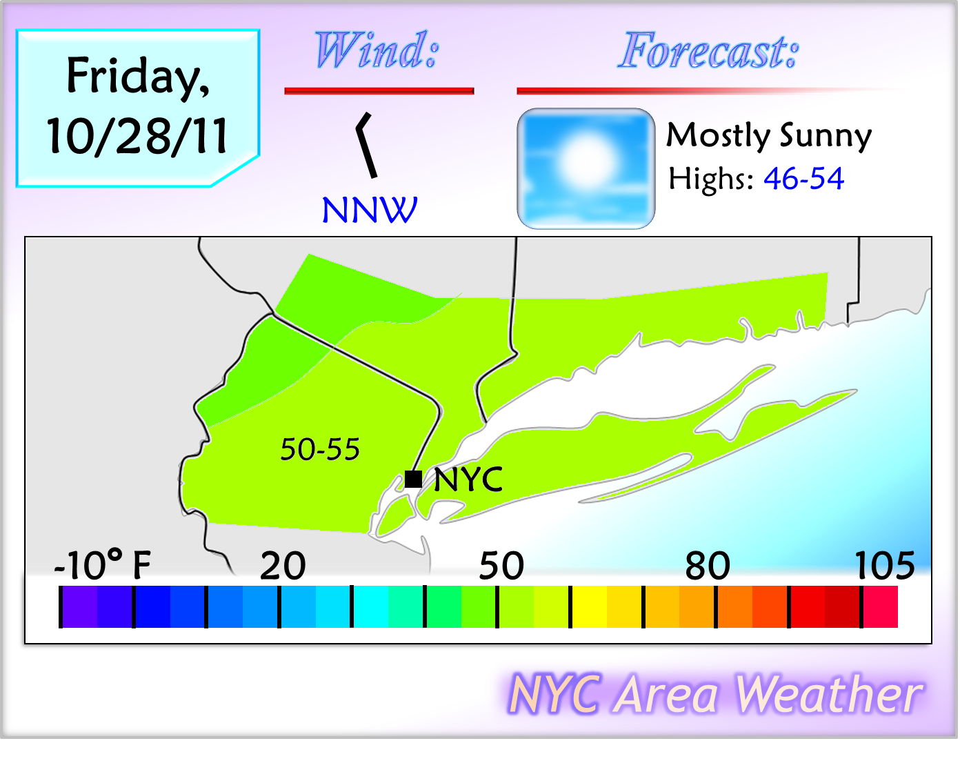
 With mostly sunny skies tomorrow and 850 mb temperatures below freezing across the entire area, the first time this has happened this fall, tomorrow will bring similar high temperatures to those of today, if not slightly warmer in some places. High temperatures are expected to reach the upper 40s to lower 50s inland and the lower 50s across the rest of the area, with some mid 50s in parts of the immediate NYC area. A NNW wind is expected.
Saturday - Saturday Night: Early Season Snowstorm Expected
The model performance for this storm has not been very good, as after showing the storm three days ago, the models considerably backed away from showing the storm two days ago, with only the ECM holding on to the strong storm idea. Yesterday's runs brought a slow west trend, but except for the UKMET, the rest of the models kept most of the storm offshore with only light precipitation affecting the coast. Despite the fact that there are only two days left until the storm affects the region, a significant last minute trend took place with the model guidance today, as the models adjusted towards a stronger and further west storm, bringing a significant early season snowstorm to parts of the region.
 The majority of today's models focused the heavy snow over the western parts of the NYC area, with the 18z NAM run even showing heavy wet snow accumulating in NYC itself, though this NAM run is likely too cold and too wet. The models continue to trend west, however, with the latest 21z SREF run likely bringing more mixing issues for coastal areas and the 18z GFS ensemble mean showing a storm closer to the coast than the operational GFS run. With the trends in mind, I went with a scenario slightly to the west of the model guidance, expecting the storm to track relatively close to the coast, bringing rain to a rain/snow mix in the area and a significant storm inland.
Forecast for the NYC Area: At this time, I am expecting light rain to begin developing in the area on Saturday morning, mixing with snow in parts of northern NJ/SE NY. The precipitation will steadily intensify, and by Saturday afternoon, a steady moderate/heavy rain is expected for NYC and Long Island, with snow mixing with the rain in southern Connecticut, NE NJ and SE NY, and mostly plain snow falling in the higher elevations of Sussex/Orange counties. By the evening, as the storm starts to move away from the coast and colder temperatures aloft move in, the western parts of the area will change over to plain snow, with a rain/snow mix in the immediate NYC area and southern CT with mostly rain falling in Long Island. The storm will end around 12-2 AM with lingering snow showers across parts of the area.
 Accumulations are still uncertain with this storm, considering that the scenario is still uncertain, but for now, I drew a preliminary potential snow map which is still subject to change. With the scenario I am expecting, a trace of snow is possible in NYC, with up to 2 inches in NE NJ and southern CT. The interior parts of the area towards NW NJ may see 3 to 6 inches of snow. The potential is there for well over 4 inches of snow with this storm, potentially up to 8-12 inches of wet snow in the higher elevations of the NE, but due to uncertainty, I kept accumulations slightly lower at this time.
In NYC, the current scenario would bring a trace of snow with perhaps some light accumulations in the colder case scenario, but even a trace of snow will make this a historic event for NYC; since records were kept in Central Park in the 1860s, only three Octobers brought accumulating snowfall. If the scenario I am currently expecting or a scenario further west verifies, a trace is likely in NYC. If a scenario near today's model consensus verifies, however, this storm may end up as the 4th storm in recorded history to bring accumulating snowfall to NYC in October.
There is still uncertainty with this storm, and the forecast is subject to change. At this time, considering that the models are still trending west, I went with a scenario slightly to the west of the latest model consensus, but the possibility is there that the current models may be correct with their scenario. Depending on the model trends, tomorrow's forecast may either go with a further west scenario, where NYC sees nearly 2 inches of heavy rain followed by back end flakes with a rain/snow mix for Sussex/Orange, or the forecast may reflect a scenario similar to the current consensus, where 3 to 7 inches of snow would fall across northern NJ with some rain in NYC changing over to a mix and a few hours of heavy wet snow, likely accumulating even in the city itself. Stay tuned for more information on this storm with two updates; the first around tomorrow afternoon, and the second tomorrow evening, along with a final scenario and snow map.
Longer Range Outlook: Behind this storm, much colder temperatures will move in, with almost the entire area dropping near or below the freezing mark on Saturday night. Low temperatures are even expected to reach the mid 20s in Sussex and Orange counties. Sunday will bring mostly sunny skies and chilly temperatures, reaching the mid 40s to lower 50s across the area. Temperatures will steadily warm up throughout next week, likely getting into the 60s around the second half of next week. The potential may be there for a storm on Tuesday/Wednesday, which the latest model guidance shows staying mostly offshore but needs to be watched as it may trend further west.
Temperatures are currently steadily dropping across the area, and fell below the 40 degree mark in the interior parts of the area. With clearing skies expected for tonight, low temperatures will drop into the lower to upper 30s across the area with some upper 20s inland, bringing the first widespread frost of the fall across the area. The cold is not the biggest story for this time frame, however, as a strong coastal low developing off the coast and moving towards the region will bring an unseasonably early snowstorm to the region including the NYC area which, if the current expectations are correct, may become historic for this time of the year.
Tomorrow's Outlook:
Saturday - Saturday Night: Early Season Snowstorm Expected
The model performance for this storm has not been very good, as after showing the storm three days ago, the models considerably backed away from showing the storm two days ago, with only the ECM holding on to the strong storm idea. Yesterday's runs brought a slow west trend, but except for the UKMET, the rest of the models kept most of the storm offshore with only light precipitation affecting the coast. Despite the fact that there are only two days left until the storm affects the region, a significant last minute trend took place with the model guidance today, as the models adjusted towards a stronger and further west storm, bringing a significant early season snowstorm to parts of the region.

Forecast for the NYC Area: At this time, I am expecting light rain to begin developing in the area on Saturday morning, mixing with snow in parts of northern NJ/SE NY. The precipitation will steadily intensify, and by Saturday afternoon, a steady moderate/heavy rain is expected for NYC and Long Island, with snow mixing with the rain in southern Connecticut, NE NJ and SE NY, and mostly plain snow falling in the higher elevations of Sussex/Orange counties. By the evening, as the storm starts to move away from the coast and colder temperatures aloft move in, the western parts of the area will change over to plain snow, with a rain/snow mix in the immediate NYC area and southern CT with mostly rain falling in Long Island. The storm will end around 12-2 AM with lingering snow showers across parts of the area.

In NYC, the current scenario would bring a trace of snow with perhaps some light accumulations in the colder case scenario, but even a trace of snow will make this a historic event for NYC; since records were kept in Central Park in the 1860s, only three Octobers brought accumulating snowfall. If the scenario I am currently expecting or a scenario further west verifies, a trace is likely in NYC. If a scenario near today's model consensus verifies, however, this storm may end up as the 4th storm in recorded history to bring accumulating snowfall to NYC in October.
There is still uncertainty with this storm, and the forecast is subject to change. At this time, considering that the models are still trending west, I went with a scenario slightly to the west of the latest model consensus, but the possibility is there that the current models may be correct with their scenario. Depending on the model trends, tomorrow's forecast may either go with a further west scenario, where NYC sees nearly 2 inches of heavy rain followed by back end flakes with a rain/snow mix for Sussex/Orange, or the forecast may reflect a scenario similar to the current consensus, where 3 to 7 inches of snow would fall across northern NJ with some rain in NYC changing over to a mix and a few hours of heavy wet snow, likely accumulating even in the city itself. Stay tuned for more information on this storm with two updates; the first around tomorrow afternoon, and the second tomorrow evening, along with a final scenario and snow map.
Longer Range Outlook: Behind this storm, much colder temperatures will move in, with almost the entire area dropping near or below the freezing mark on Saturday night. Low temperatures are even expected to reach the mid 20s in Sussex and Orange counties. Sunday will bring mostly sunny skies and chilly temperatures, reaching the mid 40s to lower 50s across the area. Temperatures will steadily warm up throughout next week, likely getting into the 60s around the second half of next week. The potential may be there for a storm on Tuesday/Wednesday, which the latest model guidance shows staying mostly offshore but needs to be watched as it may trend further west.
Winter 2011-2012 Preliminary Outlook
NYC Area Weather
With an early season snowstorm expected to affect the region this weekend, bringing the first snow of the season into parts of the NYC area, it is time to start looking at the upcoming winter. Long range forecasting is not exact, and can be incorrect, but it does give a general idea on what we can expect for the winter. Last year’s winter outlook was incorrect in many ways, with the winter turning out to be a historic winter bringing two of the biggest snowstorms in Central Park’s recorded history. Last winter’s forecast, however, was more complicated due to a lack of historical analogs to look back at; strong La Niña’s are relatively uncommon, and most of them produced below average snowfall in New York City. Although there are uncertainties with this winter’s outlook as well, there are more hints and historical references that are providing more clues to what this winter might bring.
A. Factors Behind The Forecast
1. La Niña
The ENSO isn’t the only factor that decides the outcome for the winter, though it does play a significant role. There are three different ENSO states: La Niña, neutral, and El Niño. Sea surface temperature departures near the equator in the eastern Pacific are used to determine whether a La Niña or an El Niño is in place, with that specific region separated into four regions: ENSO regions 4 and 3.4 are to the west, with regions 3 and 1+2 further east. Below is a graphic from the CPC showing these regions:

If ENSO region 3.4 averages at least 0.5 degree Celsius below normal for five consecutive months, there is a La Niña in place. If ENSO region 3.4 is at least 0.5 degree Celsius above normal, there is an El Niño in place. For this winter, we are dealing with a La Niña. Over this summer and fall, a La Niña developed again, making this winter a second consecutive La Niña, after last winter’s borderline strong La Niña. The La Niña is still developing and slightly weakened earlier this month, although it is intensifying again. I am expecting the La Niña to continue to intensify throughout the rest of this fall into the early winter with departures of at least -1.0 to -1.3 degrees Celsius, making this winter a moderate La Niña.
An average La Niña can result in a warmer than wetter than average winter in the Mid Atlantic, warmer and drier than average conditions in the South, and a colder and stormier than average northern US. Not every La Niña is the same, however, as the location of the coldest departures with the La Niña is important as well. Looking back at the graphic above showing the ENSO regions, the La Niña can either be east based, basin wide, or west based. If the coldest departures are focused in the western regions, the La Niña is west based; the opposite applies for an east based La Niña. A basin wide La Niña is observed when the coldest departures are spread throughout the ENSO regions. A west based La Niña, as we saw during the winter of 2007-2008, often results in a ridge near the East Coast with above average temperatures, with the colder departures focused towards the north central/NW US. An east based La Niña, as we saw during last year’s winter, often results in a colder and sometimes snowier than average winter for the East Coast. Currently, the La Niña is basin wide, fluctuating between slightly east and slightly west based, which can result in a scenario in between the two scenarios previously mentioned. At this time, I am expecting the La Niña to remain mainly basin wide throughout the winter.
2. Teleconnections
To create this winter forecast, I used some teleconnections and other factors, with the two important factors discussed below.
a. NAO
The NAO, or the North Atlantic Oscillation, is an index that can either be positive or negative, and its phase is determined by the North Atlantic pattern. A positive NAO is present when there is a trough near Greenland, keeping the cold air over Canada, and often results in a ridge along with warmer than average temperatures in the eastern US. A negative NAO is present when there is a ridge near Greenland, which displaces the cold air further south and blocks it with more frequent below average temperatures in the central/eastern US. A negative NAO alone does not indicate colder than average temperatures, as the negative NAO can be either east or west based. An east based –NAO has the ridging to the east of Greenland, which typically brings less cold into the East US with a further west storm track, while a west based –NAO has the ridging to the west of Greenland, and brings a higher probability of below average temperatures in the East coast. At this time, it is more difficult to determine whether the NAO will be east or west based this winter, but it is a factor that should be kept in mind during the winter months.
Over the last two winters, there has been a strong –NAO signal. This contributed to the colder and snowier than average winters the Mid Atlantic has experienced. Looking back at other La Niña winters, the winter of 2007-2008 featured a positive NAO, which contributed to a warmer than average winter in the East. This summer and fall, however, the –NAO signal has weakened, and a positive NAO is beginning to show up more frequently. Although a negative NAO is expected for this winter, the –NAO isn’t expected to be as strong as the last few years. For this winter, I am expecting the NAO to average out as slightly negative, with occasional periods of a positive NAO at times.
b. PNA
Another factor for this winter is the PNA, or the Pacific/North American Pattern. A positive PNA is associated with a ridge near the West Coast, and a negative PNA is associated with a trough near the West Coast. The PNA often reflects what happens in the central and eastern US; a +PNA often translates into a central/eastern US trough with colder than average temperatures, and a –PNA often translates into a central/eastern US ridge with warmer than average temperatures. A +PNA and –NAO combination is indicative of cold and potentially snowy conditions for the Mid Atlantic and Northeast US, though +PNA/+NAO and –PNA/-NAO combinations are possible as well.
Over the last two winters, the PNA has been mostly positive, which combined with the negative NAO, contributed to the cold and snowy winters the Mid-Atlantic and Northeast US have observed. As with the NAO analogs, the winter of 2007-2008 as well as 1988-1989 featured a negative PNA, which resulted in warmer and less snowy than average conditions in the eastern US. So far this fall, we have seen a mainly negative PNA, with occasional periods of a positive PNA. For this winter, I am expecting the PNA to average out to at least neutral or slightly negative, with some periods of a positive PNA at times.
B. Winter Comparisons
In addition to the factors mentioned above, analog years are also considered when making the winter forecast. For this winter, a weak-moderate La Niña is expected along with a slightly negative NAO, neutral PNA, and a negative PDO. Some La Niñas that can be compared to this winter include 2007-08 and 2008-09. Last winter was also a La Niña, but considering that the –NAO and –AO signal was much stronger last winter, the La Niña was more east based, and was stronger than this year’s La Niña, a repeat of last winter’s extreme snowfall in the northern Mid Atlantic and southern New England is unlikely for this winter.
The winter of 2007-08 has some similarities to this winter, including a –PDO pattern. That winter, however, brought a consistently positive NAO and a negative PNA, with a strong ridge in the southeastern US pushing the storm track inland during most of the winter months. That La Niña was also stronger than the current La Niña, as by this time of the year in 2007, there was already a well-organized, strong and west based La Niña. The La Niña of 2008-09, which brought slightly above average snowfall to the NYC area, has more similarities to this winter, as it was also a second year La Niña, and brought a –NAO and a slightly positive PNA. That La Niña, however, was weaker than this year, and fell short of the criteria for an official La Niña. With all of the factors considered, this La Niña may have some similarities to the two winters mentioned above, but is unlikely to be as warm as 2007-08. At the same time, a less extreme version of last winter is possible, leading to the conclusion that the above average snow zone will likely extend further west next winter, but above average snow is still possible in the region along with slightly below average temperatures.
C. Outlook for the United States
When putting the factors mentioned previously into a single forecast, signs point to another active winter in the United States, but with the focus of the snow towards the Great Lakes, Ohio Valley and the Northeast, unlike the last two winters which focused the snow over the Mid Atlantic. Regardless, with a negative NAO signal likely to continue along with a slightly negative NAO and a neutral PNA, positive at times, snowstorms will still affect the Mid-Atlantic region, with slightly above average snow and slightly colder than average temperatures possible for this winter. The coldest departures for this winter will likely focus over the north central US into the Great Lakes and the Ohio Valley, with warmer than average temperatures over the southern and SW US as well as parts of the SE US. Above average precipitation is likely for the central US into the Ohio Valley, Great Lakes, Mid Atlantic and the Northeast, with below average precipitation for the southern and SW US.
For the northern Mid-Atlantic region, including NYC, a slight colder and snowier than average winter is possible. There is more uncertainty this far out with the month by month outlook, but a cold and snowy start to the winter may be possible as with last winter, with a slightly warmer pattern for the second half of the winter. There will be more frequent warm ups than last winter as some of the storms track to the west of the coast, either near the Great Lakes/Ohio Valley or over the I-95 corridor, bringing rain to the East Coast including the area, but coastal lows are expected as well, which may bring the total snow this winter to slightly above average. Forecasting the more specific snowfall amounts is more difficult, however, as only one big storm could change the entire forecast as last year’s December 26-27 blizzard proved.
Preliminary Temperature Departure Map:

Preliminary Precipitation Departure Map:

Preliminary Snow Departure Map:

This is only the preliminary outlook, and is still subject to some changes. Stay tuned for the final winter outlook which will be posted around the middle of November, discussing more of the factors used for the forecast and going more in-depth on the forecast itself, including a month by month outlook.
Oct 27, 2011 Noon Update
The model guidance trended significantly to the west last night with the weekend storm after I posted my update last night, and as the update mentioned that a further west scenario will lead to snow mixing with the rain north/west of NYC, the potential now exists for the first significant snowstorm of the winter across the region, including parts of the NYC area.
There is still some uncertainty as the change in the expectation is only recent, but if the latest expected scenario verifies, accumulating snow will fall to the north and west of NYC, with several inches of snow towards NW NJ and SE NY. I issued a Light Snow Alert for the interior parts of the area, but the alert is conservative at this time due to uncertainty, and will likely be upgraded to a Snow Warning (3 to 7 inches of snow) this evening if no major changes take place with the expected scenario.
Stay tuned for additional coverage of this change in the forecast later today:
- 4:00 PM: Updated 5-Day Forecast
- 7:00 PM: Preliminary winter outlook will be posted / Updated snow alerts
- 10:00 PM: Full length discussion on storm, including preliminary scenario and snow maps.
Wednesday, October 26, 2011
Oct 26, 2011: Cold Spell Starts Tomorrow Night
NOTES:
- The 2010-11 preliminary winter outlook will be posted late tomorrow afternoon.
- Two polls have been opened; the first is for snow in the NYC tri-state area for this week, and the second is for the outlook for this weekend. Please vote your thoughts on these storms in the polls, with the first poll closing tomorrow night and the second one closing on Friday night.
----------------------------------------------------------------
With a weak wave of low pressure moving into the Northeast, today brought mostly cloudy skies and similar temperatures to those of yesterday, reaching the upper 50s to lower 60s inland and the lower to mid 60s across the rest of the area. Despite the mainly cloudy skies, no rain was observed across the area today as the precipitation stayed in the northern Northeast, where scattered showers fell and even some light snow was observed in some of the higher elevations.
A strong cold air mass currently over southern Canada will begin to move into the northeastern US tonight, and will be pushed into the region behind a wave of low pressure moving through the region tomorrow, bringing light to moderate snow across parts of the Northeast and a cold rain to the NYC area. Behind this wave of low pressure, several days of near to below freezing overnight lows are expected, with the first widespread frost and freeze of this fall taking place during this time frame other than a risk of showers for Saturday. The cold won't last for a long period of time, however, as temperatures will begin to moderate towards the first week of November.
Tomorrow's Outlook:
 With the wave of low pressure moving into the region, the NYC area is expected to see occasional showers throughout the day, especially towards the evening, amounting to about 1/2 to 3/4 inch of rain with locally higher amounts possible. With the cold air mass slowly pushing south throughout the day, temperatures will steadily cool down, with the peak temperatures of the day expected to take place tonight with temperatures reaching the lower to upper 50s. During the day hours tomorrow, temperatures are expected to peak in the morning, reaching the mid to upper 40s inland, upper 40s to lower 50s in the immediate NYC area and southern CT, and in the lower to mid 50s in Long Island. Temperatures will continue to steadily cool down, and by 8 PM, will fall below the 40 degree mark across most of northern NJ, SE NY and southern CT.
Looking across the rest of the region, the wave of low pressure will be responsible for producing the first widespread snow event of this fall in the Northeast. The cold air mass is not a very strong one with the cold only coming in towards the end of the storm, meaning that significant accumulations are not expected in the Northeast, but a general 1 to 4 inches of snow are likely to fall in the higher elevations of the Northeast, especially towards western Massachusetts and the Catskills in NY. For the lower elevations of southern New England away from the immediate coast, rain is expected during the day tomorrow, which will likely mix with show showers tomorrow night as the storm begins to move offshore. Snow is unlikely in the NYC tri-state area, but the potential is there for some flakes to mix with the rain in parts of Sussex and Orange counties. Unless there is a significant change in the forecast, storm updates will not be posted tomorrow as the winter outlook will be posted.
Friday - Sunday: Widespread Frost/Freeze Expected; Update On Storm Potential
A strong air mass will move into the region behind the storm, and with clearing skies, cold temperatures are expected for tomorrow night, dropping into the upper 20s to lower 30s in NW NJ/Orange county, lower to mid 30s across the rest of SE NY, NE NJ and southern CT, mid 30s in Long Island, and upper 30s in NYC. Friday will bring more sunshine, with mostly sunny skies and high temperatures reaching the upper 40s to lower 50s across the area. Cold temperatures are expected again for Friday night, and with a high pressure providing mostly clear skies, low temperatures will be similar to those of Thursday night, bringing the first risk of a widespread frost and freeze across the area. Most places that have not seen their first frost yet will most likely have frost between Thursday night and Saturday night.
The biggest uncertainty for this weekend is for a storm potential on Saturday and Saturday night. This storm potential became the focus of attention for this weekend 2 days ago, when the majority of the models showed a significant nor'easter affecting the region, but yesterday's models significantly backed away, with the ECMWF the only model holding on to the strong storm idea with the rest of the model guidance staying offshore. Today's model runs trended back slightly to the west, with the GFS showing a light rain event, the UKMET showing a more significant storm, and the CMC trending slightly to the west. The ECMWF model, however, backed away from its solution of a big storm and went towards a solution closer to that of the GFS.
When looking at the latest model runs and considering that there are about 3 days left until the storm affects the region, it appears that the models may be reaching an agreement on the overall scenario for the storm, with a weak low pressure bringing light rain to coastal areas with the bulk of the storm staying offshore. Although this set up is supportive of a storm coming up the coast, there are many other variables that have to end up in the right positions in order for a significant nor'easter to affect the region. In addition, the storm is not expected to be very amplified, with almost every model showing a weak, broad area of low pressure near eastern North Carolina, when the scenearios that showed a big storm moving up the coast already had a stronger, more organized low pressure near eastern NC. It is very possible that we may see additional west adjustments on the models, but unless we see more noticeable changes with the set up towards more amplification, it is unlikely that the models trend towards anything more than light-moderate rain along the I-95 corridor.
Considering the latest trends and the set up, I am currently going with a scenario slightly to the west of the model consensus, expecting cloudy skies with light rain affecting the area, especially further east towards Long Island where moderate rain is possible. Chilly high temperatures are expected, likely reaching the mid 40s to lower 50s across the area. The rain would end by Saturday night as skies clear and temperatures drop again to near/below freezing levels. There is still uncertainty with the storm as the models are still having issues with handling the set up across the US, and the potential is there that we may either see a weak storm, in which case the area sees partly cloudy skies and highs in the lower to mid 50s, or we may see a stronger storm closer to the coast, in which case we would see moderate rain, likely mixing with wet snow north/west of NYC, with high temperatures in the lower to mid 40s. Stay tuned for more information on the potential weekend storm.
Next Week: Warming Up, Stormy Start To November?
The cold air mass will begin to weaken behind Saturday's potential storm, but enough cold air will still be in place for a chilly Halloween, with high temperatures in the lower to mid 50s across most of the area for Monday along with partly sunny skies. Cloud cover will increase by Monday night, however, as a potential storm may approach the region. The latest models are showing the potential for a strong low pressure to affect the region on Tuesday and Wednesday, but with the cold air mass significantly weakening by that time, any precipitation will fall in the form of rain. There is uncertainty with the location of this storm, considering that the models still first have to nail down the weekend storm's location, but the potential is there for rain to affect the area on both days, followed by warming temperatures for the second half of next week, potentially returning into the 60s. Stay tuned for more information on the longer range.
- The 2010-11 preliminary winter outlook will be posted late tomorrow afternoon.
- Two polls have been opened; the first is for snow in the NYC tri-state area for this week, and the second is for the outlook for this weekend. Please vote your thoughts on these storms in the polls, with the first poll closing tomorrow night and the second one closing on Friday night.
----------------------------------------------------------------
With a weak wave of low pressure moving into the Northeast, today brought mostly cloudy skies and similar temperatures to those of yesterday, reaching the upper 50s to lower 60s inland and the lower to mid 60s across the rest of the area. Despite the mainly cloudy skies, no rain was observed across the area today as the precipitation stayed in the northern Northeast, where scattered showers fell and even some light snow was observed in some of the higher elevations.
A strong cold air mass currently over southern Canada will begin to move into the northeastern US tonight, and will be pushed into the region behind a wave of low pressure moving through the region tomorrow, bringing light to moderate snow across parts of the Northeast and a cold rain to the NYC area. Behind this wave of low pressure, several days of near to below freezing overnight lows are expected, with the first widespread frost and freeze of this fall taking place during this time frame other than a risk of showers for Saturday. The cold won't last for a long period of time, however, as temperatures will begin to moderate towards the first week of November.
Tomorrow's Outlook:

Looking across the rest of the region, the wave of low pressure will be responsible for producing the first widespread snow event of this fall in the Northeast. The cold air mass is not a very strong one with the cold only coming in towards the end of the storm, meaning that significant accumulations are not expected in the Northeast, but a general 1 to 4 inches of snow are likely to fall in the higher elevations of the Northeast, especially towards western Massachusetts and the Catskills in NY. For the lower elevations of southern New England away from the immediate coast, rain is expected during the day tomorrow, which will likely mix with show showers tomorrow night as the storm begins to move offshore. Snow is unlikely in the NYC tri-state area, but the potential is there for some flakes to mix with the rain in parts of Sussex and Orange counties. Unless there is a significant change in the forecast, storm updates will not be posted tomorrow as the winter outlook will be posted.
Friday - Sunday: Widespread Frost/Freeze Expected; Update On Storm Potential
A strong air mass will move into the region behind the storm, and with clearing skies, cold temperatures are expected for tomorrow night, dropping into the upper 20s to lower 30s in NW NJ/Orange county, lower to mid 30s across the rest of SE NY, NE NJ and southern CT, mid 30s in Long Island, and upper 30s in NYC. Friday will bring more sunshine, with mostly sunny skies and high temperatures reaching the upper 40s to lower 50s across the area. Cold temperatures are expected again for Friday night, and with a high pressure providing mostly clear skies, low temperatures will be similar to those of Thursday night, bringing the first risk of a widespread frost and freeze across the area. Most places that have not seen their first frost yet will most likely have frost between Thursday night and Saturday night.
The biggest uncertainty for this weekend is for a storm potential on Saturday and Saturday night. This storm potential became the focus of attention for this weekend 2 days ago, when the majority of the models showed a significant nor'easter affecting the region, but yesterday's models significantly backed away, with the ECMWF the only model holding on to the strong storm idea with the rest of the model guidance staying offshore. Today's model runs trended back slightly to the west, with the GFS showing a light rain event, the UKMET showing a more significant storm, and the CMC trending slightly to the west. The ECMWF model, however, backed away from its solution of a big storm and went towards a solution closer to that of the GFS.
When looking at the latest model runs and considering that there are about 3 days left until the storm affects the region, it appears that the models may be reaching an agreement on the overall scenario for the storm, with a weak low pressure bringing light rain to coastal areas with the bulk of the storm staying offshore. Although this set up is supportive of a storm coming up the coast, there are many other variables that have to end up in the right positions in order for a significant nor'easter to affect the region. In addition, the storm is not expected to be very amplified, with almost every model showing a weak, broad area of low pressure near eastern North Carolina, when the scenearios that showed a big storm moving up the coast already had a stronger, more organized low pressure near eastern NC. It is very possible that we may see additional west adjustments on the models, but unless we see more noticeable changes with the set up towards more amplification, it is unlikely that the models trend towards anything more than light-moderate rain along the I-95 corridor.
Considering the latest trends and the set up, I am currently going with a scenario slightly to the west of the model consensus, expecting cloudy skies with light rain affecting the area, especially further east towards Long Island where moderate rain is possible. Chilly high temperatures are expected, likely reaching the mid 40s to lower 50s across the area. The rain would end by Saturday night as skies clear and temperatures drop again to near/below freezing levels. There is still uncertainty with the storm as the models are still having issues with handling the set up across the US, and the potential is there that we may either see a weak storm, in which case the area sees partly cloudy skies and highs in the lower to mid 50s, or we may see a stronger storm closer to the coast, in which case we would see moderate rain, likely mixing with wet snow north/west of NYC, with high temperatures in the lower to mid 40s. Stay tuned for more information on the potential weekend storm.
Next Week: Warming Up, Stormy Start To November?
The cold air mass will begin to weaken behind Saturday's potential storm, but enough cold air will still be in place for a chilly Halloween, with high temperatures in the lower to mid 50s across most of the area for Monday along with partly sunny skies. Cloud cover will increase by Monday night, however, as a potential storm may approach the region. The latest models are showing the potential for a strong low pressure to affect the region on Tuesday and Wednesday, but with the cold air mass significantly weakening by that time, any precipitation will fall in the form of rain. There is uncertainty with the location of this storm, considering that the models still first have to nail down the weekend storm's location, but the potential is there for rain to affect the area on both days, followed by warming temperatures for the second half of next week, potentially returning into the 60s. Stay tuned for more information on the longer range.
Tuesday, October 25, 2011
Oct 25, 2011: Cold Rain For Thursday
Behind last night's weak cold front, which brought isolated showers across the region, today brought mostly sunny skies across the area with high temperatures reaching the lower 60s inland and the lower to mid 60s across the rest of the area. Cold temperatures are expected again tonight, dropping into the upper 30s in the interior parts of the area with 40s across the rest of the area.
A weak wave of low pressure moving into the southern Great Lakes will bring increased cloud cover for tomorrow with the risk of isolated showers. Cold air will slowly drop into the Northeast, and combined with a wave of low pressure moving into the region on Thursday, a chilly moderate rain is expected across the area with high temperatures struggling to reach the lower 50s, and parts of New England, New York and Pennsylvania are even expected to see accumulating snow with several inches possible. A strong high pressure will build in behind the storm to bring colder temperatures and the first freeze potential for the area, but even though the potential for a storm this weekend has become less clear, the possibility is still there.
Tomorrow's Outlook:
 With the wave of low pressure previously mentioned moving towards the region, increased cloud cover is expected with SW winds expected. Combined with mostly cloudy skies and 850 mb temperatures near 9-11 degrees celsius, high temperatures will reach the lower 60s inland and the lower to mid 60s across the rest of the area. In the warmer case scenario, places near and southwest of NYC may pass the 65 degree mark.
Thursday - Friday: Rain, Then Cold
The low pressure near the Great Lakes will fail to move into the region, and instead, a stronger wave of low pressure will develop near the southern Ohio Valley and move towards New Jersey on Thursday. This wave of low pressure will have a colder air mass to its north, as a dropping trough behind this storm will bring below freezing 850 mb temperatures in the Northeast while the precipitation falls. This set up is supportive of an early season snow event in the Northeast and a chilly rain for the NYC area. Rain is expected to develop in the area late tomorrow night, with a steady light to moderate rain falling throughout the day on Thursday. High temperatures will be unusually chilly, reaching the mid to upper 40s inland, upper 40s to lower 50s in the immediate NYC area, and the lower to mid 50s east of NYC. The rain will continue until at least 12-2 AM before ending, with a storm total between 1/2 and 1 inch of rain expected.
This storm will also bring the first widespread snow event of this fall into the Northeast. The combination of cold air and a high pressure to the NW of the storm will result in a widespread rain/snow mix falling in central New England, most of New York state, and parts of northern Pennsylvania. The higher elevations will likely change over to plain snow, with 2 to 4 inches of wet snow possible. As the storm exits the region, any rain will likely change over to a mix of rain and snow across New England except for the immediate coast, and if the changeover happens fast enough, parts of Sussex and Orange counties may see some flakes on Thursday night. Behind the storm, colder air will move into the region, and low temperatures will drop into the lower 30s inland, mid to upper 30s in NE NJ and southern CT and upper 30s to mid 40s in Long Island/NYC. Stay tuned for more information on this storm, including a regional snow map, with tomorrow's update.
Weekend: Storm Or No Storm?
The outlook for this weekend is more uncertain, however, as the latest models continue to go back and forth with the storm. Two days ago, no hints of a storm were shown on the models. Yesterday, over half of the model guidance trended to show a significant coastal storm with snow in parts of the region, even down to the coast. Today's models, however, quickly went back, with the GFS, CMC and UKMET models back to showing a weak coastal low staying well offshore. The ECMWF is the only model staying consistent with a significant coastal storm idea, bringing accumulating snowfall into the immediate north/west suburbs of NYC which seem to be reasonable given the set up that it shows, but the ECMWF ensemble mean is well to the east of the operational run. The latest models showed only slight hints of a west trend, however, as the 18z GFS showed a slightly further west and stronger storm with more individual ensemble members showing a stronger storm idea.
With Hurricane Rina in the western Caribbean moving towards the Gulf of Mexico at the same time that the shortwave responsible for this potential storm will be near the southern US, Rina appears to be a part of the equation for this storm as well. The 12z GFS, which kept the storm well offshore, is an outlier as it brings Rina into Florida while the model consensus keeps Rina near Cuba, but there are signs showing that the ECM is an outlier with how it handles Rina, as it quickly dissipates the hurricane within the next two days. Considering that Rina is an intensifying category 2 hurricane, the ECM is clearly having issues with handling Rina, while most of the other models, which happen to be the same ones keeping the coastal storm offshore, do not weaken Rina and take it into Cuba. While Rina is not the only part of determining whether we see an offshore storm or a strong nor'easter, as the intensity and timing of the shortwave in the southern US also need to be considered, it appears at this time that a more likely scenario may be a coastal low staying offshore, with partly cloudy skies near the coast. At this time, I went slightly to the west of the model consensus, putting a risk of showers in the forecast, but there is still uncertainty, and it is possible that I may remove the rain chances from the forecast, or if the models trend back west, increase rain chances and add a mention of snow for the interior parts of the area. Stay tuned for more information on the weekend potential storm.
A weak wave of low pressure moving into the southern Great Lakes will bring increased cloud cover for tomorrow with the risk of isolated showers. Cold air will slowly drop into the Northeast, and combined with a wave of low pressure moving into the region on Thursday, a chilly moderate rain is expected across the area with high temperatures struggling to reach the lower 50s, and parts of New England, New York and Pennsylvania are even expected to see accumulating snow with several inches possible. A strong high pressure will build in behind the storm to bring colder temperatures and the first freeze potential for the area, but even though the potential for a storm this weekend has become less clear, the possibility is still there.
Tomorrow's Outlook:

Thursday - Friday: Rain, Then Cold
The low pressure near the Great Lakes will fail to move into the region, and instead, a stronger wave of low pressure will develop near the southern Ohio Valley and move towards New Jersey on Thursday. This wave of low pressure will have a colder air mass to its north, as a dropping trough behind this storm will bring below freezing 850 mb temperatures in the Northeast while the precipitation falls. This set up is supportive of an early season snow event in the Northeast and a chilly rain for the NYC area. Rain is expected to develop in the area late tomorrow night, with a steady light to moderate rain falling throughout the day on Thursday. High temperatures will be unusually chilly, reaching the mid to upper 40s inland, upper 40s to lower 50s in the immediate NYC area, and the lower to mid 50s east of NYC. The rain will continue until at least 12-2 AM before ending, with a storm total between 1/2 and 1 inch of rain expected.
This storm will also bring the first widespread snow event of this fall into the Northeast. The combination of cold air and a high pressure to the NW of the storm will result in a widespread rain/snow mix falling in central New England, most of New York state, and parts of northern Pennsylvania. The higher elevations will likely change over to plain snow, with 2 to 4 inches of wet snow possible. As the storm exits the region, any rain will likely change over to a mix of rain and snow across New England except for the immediate coast, and if the changeover happens fast enough, parts of Sussex and Orange counties may see some flakes on Thursday night. Behind the storm, colder air will move into the region, and low temperatures will drop into the lower 30s inland, mid to upper 30s in NE NJ and southern CT and upper 30s to mid 40s in Long Island/NYC. Stay tuned for more information on this storm, including a regional snow map, with tomorrow's update.
Weekend: Storm Or No Storm?
The outlook for this weekend is more uncertain, however, as the latest models continue to go back and forth with the storm. Two days ago, no hints of a storm were shown on the models. Yesterday, over half of the model guidance trended to show a significant coastal storm with snow in parts of the region, even down to the coast. Today's models, however, quickly went back, with the GFS, CMC and UKMET models back to showing a weak coastal low staying well offshore. The ECMWF is the only model staying consistent with a significant coastal storm idea, bringing accumulating snowfall into the immediate north/west suburbs of NYC which seem to be reasonable given the set up that it shows, but the ECMWF ensemble mean is well to the east of the operational run. The latest models showed only slight hints of a west trend, however, as the 18z GFS showed a slightly further west and stronger storm with more individual ensemble members showing a stronger storm idea.
With Hurricane Rina in the western Caribbean moving towards the Gulf of Mexico at the same time that the shortwave responsible for this potential storm will be near the southern US, Rina appears to be a part of the equation for this storm as well. The 12z GFS, which kept the storm well offshore, is an outlier as it brings Rina into Florida while the model consensus keeps Rina near Cuba, but there are signs showing that the ECM is an outlier with how it handles Rina, as it quickly dissipates the hurricane within the next two days. Considering that Rina is an intensifying category 2 hurricane, the ECM is clearly having issues with handling Rina, while most of the other models, which happen to be the same ones keeping the coastal storm offshore, do not weaken Rina and take it into Cuba. While Rina is not the only part of determining whether we see an offshore storm or a strong nor'easter, as the intensity and timing of the shortwave in the southern US also need to be considered, it appears at this time that a more likely scenario may be a coastal low staying offshore, with partly cloudy skies near the coast. At this time, I went slightly to the west of the model consensus, putting a risk of showers in the forecast, but there is still uncertainty, and it is possible that I may remove the rain chances from the forecast, or if the models trend back west, increase rain chances and add a mention of snow for the interior parts of the area. Stay tuned for more information on the weekend potential storm.
Monday, October 24, 2011
Oct 24, 2011: Cold, Stormy End To Week
As last night brought less cloud cover than expected, the low temperature forecast busted once again but this time on the warm side, as temperatures dropped into the upper 30s in the interior parts of the area. High temperatures today also busted on the warm side, reaching the lower 60s inland and the lower to mid 60s across the rest of the area, with temperatures aloft not ending up as warm as I expected.
Today and tomorrow will be the warmest days in the area until early November, as a wave of low pressure on Wednesday will bring light rain followed by colder temperatures. There is more uncertainty on the forecast for Thursday with another wave of low pressure and the weekend with a potential nor'easter, but with stronger cold air in the region as well, the region will experience an early taste of winter for the end of this week, with not one, but two snow potentials in parts of the region.
Tomorrow's Outlook:
After a weak cold front moves through tonight, bringing isolated showers in parts of the area, tomorrow will bring more sunshine but colder temperatures aloft, resulting in temperatures similar to those of today. High temperatures tomorrow are expected to reach the lower 60s inland and the lower to mid 60s across the rest of the area. A northwest wind is expected.
Storm #1: Wednesday - Friday
The first storm will affect the region between Wednesday and Friday. A weak low pressure will move through the southern Great Lakes on Wednesday, but will weaken into a broad area of low pressure by the time that it reaches the region on Wednesday afternoon. This will bring widespread light showers with high temperatures reaching the upper 50s to lower 60s across most of the area. During this time, a stronger wave of low pressure will organize near the southern Ohio Valley, with cold air slowly dropping further south.
 The second wave of low pressure will organize itself on Thursday, bringing a more widespread precipitation event across the region. There is some uncertainty with the track of this storm, but at this time, I am leaning slightly towards the northern solutions, expecting the storm to track from West Virginia to central NJ and then offshore, just south of New England. The NYC area is expected to see light rain developing on Wednesday night, with steady light to moderate rain on Thursday into Thursday night until at least 12 AM. Due to the rain and chilly air mass, colder temperatures are expected, likely reaching the upper 40s to lower 50s inland, lower to mid 50s in the immediate north/west suburbs of NYC, and in the mid to upper 50s from NYC and further east. By the time that the storm ends, at least 1/2 to 1 inch of rain is expected.
 Last night's update did not mention any storm risk for Saturday, as the model guidance was consistent in showing a strong high pressure over the region. Last night's 18z GFS model run, however, began showing signs of a weak low pressure offshore, and trended closer to a phase until today's runs, which showed a stronger storm in some cases. The 00z/12z ECMWF, 12z GFS and 12z CMC runs showed the low pressure near the coast, with the ECM producing a significant snowstorm for the Northeast and even accumulating snowfall north and west of NYC. Meanwhile, the latest GFS run fails to show anything significant, with only a weak low pressure well offshore.
At this time, there is still a lot of uncertainty with the location and the phasing of the storm, as the storm only recently started to show up on the models, and it may not be until the middle of this week when the models start to get a better handle on this storm. Until then, two main solutions are possible, the first where we see a weak storm staying offshore with mostly sunny skies and chilly temperatures across the area; the second scenario would bring a stronger nor'easter up the coast, producing widespread rain for the coast and potentially snow for interior areas. For now, I went with a solution in between, slightly leaning towards the second scenario, where the area sees potential rain, but the forecast is still uncertain and is subject to change. Stay tuned for more information on this weekend's outlook.
Brief Longer Range Outlook: Regardless of the storm, cold temperatures are expected across the area during the weekend, with Saturday night in the 1st storm scenario and Sunday night in the 2nd scenario bringing cold overnight temperatures across the area with widespread 30s, bringing the first widespread frost potential of this fall across the area. The cold won't last for long, however, as the teleconnections point to moderating temperatures in the East, with a warm up likely for the region around the start of November. This warm up won't last through much of November, however, as indications show that a colder pattern may set up for November than we had most of this month.
Today and tomorrow will be the warmest days in the area until early November, as a wave of low pressure on Wednesday will bring light rain followed by colder temperatures. There is more uncertainty on the forecast for Thursday with another wave of low pressure and the weekend with a potential nor'easter, but with stronger cold air in the region as well, the region will experience an early taste of winter for the end of this week, with not one, but two snow potentials in parts of the region.
Tomorrow's Outlook:
After a weak cold front moves through tonight, bringing isolated showers in parts of the area, tomorrow will bring more sunshine but colder temperatures aloft, resulting in temperatures similar to those of today. High temperatures tomorrow are expected to reach the lower 60s inland and the lower to mid 60s across the rest of the area. A northwest wind is expected.
Storm #1: Wednesday - Friday
The first storm will affect the region between Wednesday and Friday. A weak low pressure will move through the southern Great Lakes on Wednesday, but will weaken into a broad area of low pressure by the time that it reaches the region on Wednesday afternoon. This will bring widespread light showers with high temperatures reaching the upper 50s to lower 60s across most of the area. During this time, a stronger wave of low pressure will organize near the southern Ohio Valley, with cold air slowly dropping further south.
 The second wave of low pressure will organize itself on Thursday, bringing a more widespread precipitation event across the region. There is some uncertainty with the track of this storm, but at this time, I am leaning slightly towards the northern solutions, expecting the storm to track from West Virginia to central NJ and then offshore, just south of New England. The NYC area is expected to see light rain developing on Wednesday night, with steady light to moderate rain on Thursday into Thursday night until at least 12 AM. Due to the rain and chilly air mass, colder temperatures are expected, likely reaching the upper 40s to lower 50s inland, lower to mid 50s in the immediate north/west suburbs of NYC, and in the mid to upper 50s from NYC and further east. By the time that the storm ends, at least 1/2 to 1 inch of rain is expected.
With the cold air entering the storm's northern parts, however, not only rain is expected out of this storm. Temperatures aloft are expected to drop below freezing by Friday afternoon over New England, which will produce an area of a wintry mix in parts of New York and central New England, with rain for the lower elevations and rain/snow for the higher elevations. As the storm moves out on Thursday night, the colder air will continue to push southwards, resulting in a more widespread rain/snow mix for the lower elevations of New England and accumulating snowfall for the higher elevations, with several inches of snow possible. For the NYC area, the precipitation type is expected to be rain, but if the storm is at least near where my map shows it or further south, flakes may mix in with the rain in parts of Sussex and Orange counties. Stay tuned for more information on this storm and its impact on the area and the region.
Storm #2: Saturday - Sunday
 Last night's update did not mention any storm risk for Saturday, as the model guidance was consistent in showing a strong high pressure over the region. Last night's 18z GFS model run, however, began showing signs of a weak low pressure offshore, and trended closer to a phase until today's runs, which showed a stronger storm in some cases. The 00z/12z ECMWF, 12z GFS and 12z CMC runs showed the low pressure near the coast, with the ECM producing a significant snowstorm for the Northeast and even accumulating snowfall north and west of NYC. Meanwhile, the latest GFS run fails to show anything significant, with only a weak low pressure well offshore.
At this time, there is still a lot of uncertainty with the location and the phasing of the storm, as the storm only recently started to show up on the models, and it may not be until the middle of this week when the models start to get a better handle on this storm. Until then, two main solutions are possible, the first where we see a weak storm staying offshore with mostly sunny skies and chilly temperatures across the area; the second scenario would bring a stronger nor'easter up the coast, producing widespread rain for the coast and potentially snow for interior areas. For now, I went with a solution in between, slightly leaning towards the second scenario, where the area sees potential rain, but the forecast is still uncertain and is subject to change. Stay tuned for more information on this weekend's outlook.
Brief Longer Range Outlook: Regardless of the storm, cold temperatures are expected across the area during the weekend, with Saturday night in the 1st storm scenario and Sunday night in the 2nd scenario bringing cold overnight temperatures across the area with widespread 30s, bringing the first widespread frost potential of this fall across the area. The cold won't last for long, however, as the teleconnections point to moderating temperatures in the East, with a warm up likely for the region around the start of November. This warm up won't last through much of November, however, as indications show that a colder pattern may set up for November than we had most of this month.
Oct 24, 2011 Noon Update
5:15 PM: Stormy Weekend Now Expected
Since last night's update, some changes have taken place with the forecast. A colder storm is expected for Thursday than last night's update expected, with high temperatures likely in the 40s and 50s across the area. The most significant change in the forecast is for this weekend, however, as the model guidance last night and this morning began trending towards a coastal low affecting the region, which would be the first nor'easter of this fall. There is still uncertainty with this storm as this only recently showed up in the forecast, but if the latest trends continue, a significant rain event may affect the area on Saturday and Saturday night, and an accumulating snowstorm may be possible as well in the interior Northeast. Tonight's update will discuss these two storms in more detail, including storm maps.
Since last night's update, some changes have taken place with the forecast. A colder storm is expected for Thursday than last night's update expected, with high temperatures likely in the 40s and 50s across the area. The most significant change in the forecast is for this weekend, however, as the model guidance last night and this morning began trending towards a coastal low affecting the region, which would be the first nor'easter of this fall. There is still uncertainty with this storm as this only recently showed up in the forecast, but if the latest trends continue, a significant rain event may affect the area on Saturday and Saturday night, and an accumulating snowstorm may be possible as well in the interior Northeast. Tonight's update will discuss these two storms in more detail, including storm maps.
Sunday, October 23, 2011
Oct 23, 2011: Taste Of Winter Next Week, Weekend
NOTE: The winter outlook will not be posted tomorrow, as there are still parts of the outlook I need to complete. The outlook will be posted in the Long Range Outlooks page sometime around the middle or the end of this week.
---------------------------------------------------------------
Last night, the potential was mentioned for frost to affect the interior parts of the area with cold temperatures across the rest of the area. Cloud cover unexpectedly increased across the area, however, and prevented temperatures from dropping across the area. Today brought slightly warmer temperatures, reaching the upper 50s to lower 60s inland, lower to mid 60s in the immediate NYC area, and the upper 50s to lower 60s in Long Island and southern Connecticut.
Temperatures will slightly warm up tomorrow, reaching the mid to upper 60s in the immediate NYC area, with similar, if not slightly cooler temperatures expected for Tuesday. Uncertainty returns into the forecast by Wednesday, however, as two waves of low pressure will affect the region, with the second wave around Thursday night bringing widespread rain into the region and the potential for snow in parts of the Northeast US, which will be followed by the coldest temperatures so far this fall.
Tomorrow's Outlook:
 As a low pressure in SE Canada pushes out the cold air mass, temperatures will warm up tomorrow, ending up slightly warmer than average. With a south wind and mostly cloudy skies expected, high temperatures will reach the lower to mid 60s inland, mid to upper 60s in the immediate NYC area, and the lower to mid 60s across Long Island and southern Connecticut. A few isolated showers may be possible west of NYC in the evening, but otherwise the area should stay dry.
Tuesday - Wednesday: Average Temperatures Persist
A low pressure in southeastern Canada will approach the northern Northeast on Monday, which will be responsible for tomorrow's warmer temperatures. As the cold front moves through the area, isolated showers are possible on Monday night. Drier conditions will return for Tuesday with high temperatures peaking in the lower to mid 60s across the area.
On Tuesday night, a weak low pressure will move east through the southern Great Lakes, pushing a slightly warmer air mass into the region. There is some uncertainty with where this low pressure tracks, but at this time, I am expecting this low pressure to end up over southern NY on Wednesday, which will bring slightly warmer temperatures into the area, reaching the lower to mid 60s across most of the area, along with isolated showers towards the evening. Due to the uncertainty, high temperatures may end up slightly cooler than I am currently expecting.
Thursday - Friday: Storm Brings Uncertainty Into Forecast
Although no pattern change is expected to take place just yet, we will be seeing a type of set up which we haven't seen so far this fall, giving the region its first taste of winter. A strong high pressure will push southwards into the central and southern US on Wednesday, at the same time that the weak low pressure moves over the region, which will keep the storm's cold front stalled near the area for Wednesday night into Thursday as waves of light rain move ENE along the front. As a result, high temperatures on Thursday will be slightly cooler, likely reaching the upper 50s to lower 60s across most of the area, but as the frontal boundary should be near the area, any slight change in the location of the front could result in the high temperature forecast busting a few degrees too cold or warm.
The scenario will get more interesting for Thursday into Friday as a second wave of low pressure develops along the stalled front and moves ENE, towards the region. There is still uncertainty with this storm, but the models today came into better agreement than yesterday's models, now agreeing on a weaker, more progressive and further south low pressure moving through the region on Thursday night instead of Friday night. The location of the low pressure, however, is still uncertain, and ranges from the CMC which takes the storm over the southern Mid Atlantic with a few showers in the, to the northern GFS which takes the low pressure over or just north of the area with a light snow event for parts of the interior Northeast. Except for the CMC, the rest of the model guidance mainly agrees with the snow potential for the interior Northeast; only the DGEX model shows any notable snow event for the NYC area, but is an outlier solution and will likely trend towards the model agreement tomorrow morning.
When looking at the overall picture, with a high pressure and a dropping cold air mass, the low pressure is not expected to track too far north of the area, but the initial surge of cold air before Thursday's storm is not expected to be too strong, which likely won't suppress the storm entirely to the south of the area. At this time, I am leaning towards the northern solutions, with the storm's track potentially ending up near New Jersey, ranging between the Delmarva Peninsula and southern NY. Such a solution would bring widespread light to moderate rain across the area on Thursday into Thursday night, potentially between 1/2 and 1 inch, and as the storm ends, if there is still enough precipitation left when the cold air moves in, the potential may be there for flakes to fall in the interior parts of the area, towards NW NJ and Orange county, NY. This potential has a low confidence level at this time, however, and depends on the storm's location, timing and intensity.
It should be noted that there is still a fair amount of uncertainty with this storm, and considering that the models are still having issues with handling this storm, changes are still likely with the scenario over the next few days, and it may not be until Tuesday when the models converge on a solid solution. While the original idea of a strong storm seems less likely than it was before, it cannot be ruled out yet, and it is possible that we may see a stronger storm further west with heavier rain for the area, or we may see a weaker and suppressed event, keeping most of the rain to the south of the area. Stay tuned for more information on this storm and its impact on the area.
Longer Range: Colder Pattern Begins To Develop
Regardless of the intensity of the late week storm, there is high confidence that a strong cold spell drops into the region between Friday and Sunday, bringing colder than average temperatures, with a chilly Halloween possible this year. Unless we see significant changes with the set up, high temperatures are likely to end up in the upper 40s to mid 50s range across the area, with more widespread low temperatures in the 30s possible. If there are mainly clear skies, widespread frost may be possible across the area. The coldest temperatures are likely for Friday and Saturday, with moderating temperatures for Sunday and Monday.
Looking beyond next weekend at the teleconnections, the NAO and AO are expected to rise towards positive, with a negative PNA persisting. This combination suggests that a moderation in temperatures is likely sometime around the start of November, and along with the fact that the current pattern doesn't support sustained cold spells, another warm up may be possible to start November, though it does not appear at this time that a sustained warm pattern should continue through November. Stay tuned for more information on the longer range.
---------------------------------------------------------------
Last night, the potential was mentioned for frost to affect the interior parts of the area with cold temperatures across the rest of the area. Cloud cover unexpectedly increased across the area, however, and prevented temperatures from dropping across the area. Today brought slightly warmer temperatures, reaching the upper 50s to lower 60s inland, lower to mid 60s in the immediate NYC area, and the upper 50s to lower 60s in Long Island and southern Connecticut.
Temperatures will slightly warm up tomorrow, reaching the mid to upper 60s in the immediate NYC area, with similar, if not slightly cooler temperatures expected for Tuesday. Uncertainty returns into the forecast by Wednesday, however, as two waves of low pressure will affect the region, with the second wave around Thursday night bringing widespread rain into the region and the potential for snow in parts of the Northeast US, which will be followed by the coldest temperatures so far this fall.
Tomorrow's Outlook:

Tuesday - Wednesday: Average Temperatures Persist
A low pressure in southeastern Canada will approach the northern Northeast on Monday, which will be responsible for tomorrow's warmer temperatures. As the cold front moves through the area, isolated showers are possible on Monday night. Drier conditions will return for Tuesday with high temperatures peaking in the lower to mid 60s across the area.
On Tuesday night, a weak low pressure will move east through the southern Great Lakes, pushing a slightly warmer air mass into the region. There is some uncertainty with where this low pressure tracks, but at this time, I am expecting this low pressure to end up over southern NY on Wednesday, which will bring slightly warmer temperatures into the area, reaching the lower to mid 60s across most of the area, along with isolated showers towards the evening. Due to the uncertainty, high temperatures may end up slightly cooler than I am currently expecting.
Thursday - Friday: Storm Brings Uncertainty Into Forecast
Although no pattern change is expected to take place just yet, we will be seeing a type of set up which we haven't seen so far this fall, giving the region its first taste of winter. A strong high pressure will push southwards into the central and southern US on Wednesday, at the same time that the weak low pressure moves over the region, which will keep the storm's cold front stalled near the area for Wednesday night into Thursday as waves of light rain move ENE along the front. As a result, high temperatures on Thursday will be slightly cooler, likely reaching the upper 50s to lower 60s across most of the area, but as the frontal boundary should be near the area, any slight change in the location of the front could result in the high temperature forecast busting a few degrees too cold or warm.
The scenario will get more interesting for Thursday into Friday as a second wave of low pressure develops along the stalled front and moves ENE, towards the region. There is still uncertainty with this storm, but the models today came into better agreement than yesterday's models, now agreeing on a weaker, more progressive and further south low pressure moving through the region on Thursday night instead of Friday night. The location of the low pressure, however, is still uncertain, and ranges from the CMC which takes the storm over the southern Mid Atlantic with a few showers in the, to the northern GFS which takes the low pressure over or just north of the area with a light snow event for parts of the interior Northeast. Except for the CMC, the rest of the model guidance mainly agrees with the snow potential for the interior Northeast; only the DGEX model shows any notable snow event for the NYC area, but is an outlier solution and will likely trend towards the model agreement tomorrow morning.
When looking at the overall picture, with a high pressure and a dropping cold air mass, the low pressure is not expected to track too far north of the area, but the initial surge of cold air before Thursday's storm is not expected to be too strong, which likely won't suppress the storm entirely to the south of the area. At this time, I am leaning towards the northern solutions, with the storm's track potentially ending up near New Jersey, ranging between the Delmarva Peninsula and southern NY. Such a solution would bring widespread light to moderate rain across the area on Thursday into Thursday night, potentially between 1/2 and 1 inch, and as the storm ends, if there is still enough precipitation left when the cold air moves in, the potential may be there for flakes to fall in the interior parts of the area, towards NW NJ and Orange county, NY. This potential has a low confidence level at this time, however, and depends on the storm's location, timing and intensity.
It should be noted that there is still a fair amount of uncertainty with this storm, and considering that the models are still having issues with handling this storm, changes are still likely with the scenario over the next few days, and it may not be until Tuesday when the models converge on a solid solution. While the original idea of a strong storm seems less likely than it was before, it cannot be ruled out yet, and it is possible that we may see a stronger storm further west with heavier rain for the area, or we may see a weaker and suppressed event, keeping most of the rain to the south of the area. Stay tuned for more information on this storm and its impact on the area.
Longer Range: Colder Pattern Begins To Develop
Regardless of the intensity of the late week storm, there is high confidence that a strong cold spell drops into the region between Friday and Sunday, bringing colder than average temperatures, with a chilly Halloween possible this year. Unless we see significant changes with the set up, high temperatures are likely to end up in the upper 40s to mid 50s range across the area, with more widespread low temperatures in the 30s possible. If there are mainly clear skies, widespread frost may be possible across the area. The coldest temperatures are likely for Friday and Saturday, with moderating temperatures for Sunday and Monday.
Looking beyond next weekend at the teleconnections, the NAO and AO are expected to rise towards positive, with a negative PNA persisting. This combination suggests that a moderation in temperatures is likely sometime around the start of November, and along with the fact that the current pattern doesn't support sustained cold spells, another warm up may be possible to start November, though it does not appear at this time that a sustained warm pattern should continue through November. Stay tuned for more information on the longer range.
Subscribe to:
Posts (Atom)