
Saturday, December 31, 2011
Dec 31, 2011: Cold First Week Of New Year
A weak clipper moved through the region yesterday into today, bringing widespread showers across the region along with yet another round of unseasonably warm temperatures, peaking on Friday in the mid 40s to lower 50s across the area, followed by warmer temperatures today in the lower 50s inland, lower to mid 50s in the immediate NYC area, and the lower 50s in Long Island and southern Connecticut. The average high temperature for this time of the year are near the upper 30s to lower 40s.
After a dry and unseasonably mild New Year's Eve, with partly to mostly cloudy skies and temperatures in the lower 40s at midnight, one more day of mild temperatures is expected for tomorrow, with temperatures again reaching the upper 40s to lower 50s, followed by the first significant cold spell of the winter for Tuesday and Wednesday, with widespread highs in the 20s and lows in the single digits and teens. This significant cold spell is showing that there are minor changes in the pattern, but the pattern still has not changed, as a ridge in the eastern US will quickly build in behind this cold spell with high temperatures once again returning into the upper 40s and 50s towards next weekend.
Tomorrow's Outlook:
The first day of 2012 will bring unseasonably mild temperatures once again, with partly sunny skies and temperatures peaking in the upper 40s to lower 50s inland and the lower to mid 50s across the rest of the area. Cloud cover is expected to increase towards the evening hours as a cold front approaches, however only isolated showers at most are expected out of this front on Sunday night.
Monday - Wednesday: Much Colder, Windy
With the cold front east of the area, Monday will bring partly to mostly cloudy skies with the risk of an isolated shower across the area. Colder temperatures are expected, with temperatures reaching the upper 30s to lower 40s inland and lower to mid 40s across the rest of the area, along with breezy winds. Behind the cold front, however, unlike the previous cold spells over the last two months, there is nothing to prevent the arctic air in central Canada from dropping south, and as a result, very cold arctic air will spill southwards from Canada into the central and eastern United States.
The first part of the cold will be felt on Monday night into Tuesday, with temperatures on Monday night dropping into the mid 10s to lower 20s west of NYC and the lower to upper 20s from NYC and further east. With temperatures aloft steadily cooling down, temperatures on Tuesday afternoon will not rise by much, staying steady in the lower to mid 20s inland and the mid to upper 20s across the rest of the area, dropping by the late afternoon hours. Gusty winds are expected as well, with gusts up to 40 mph; combined with the cold temperatures, wind chills will stay in the upper single digits to lower 10s throughout the day inland, and in the 10s for the rest of the area.
The coldest temperatures are expected for Tuesday night. Mostly clear skies are expected, which combined with 850mb temperatures near -20 degrees Celsius, will allow temperatures to significantly drop overnight, with low temperatures expected to end up in the mid to upper single digits inland, upper 0s to mid 10s in the north/west suburbs of NYC, upper single digits to lower 10s in southern CT, upper 0s to mid 10s in Long Island, and mid to upper 10s in NYC. Combined with gusty winds, especially in the evening, wind chills will drop into the single digits across the entire area, with sub-zero wind chills possible inland. A Wind Chill Alert will likely be issued for the interior parts of the area with tomorrow's update. Cold temperatures will continue through Wednesday along with mostly sunny skies, with highs reaching the mid to upper 20s across the area.
Longer Range: Warming Up Again
The fact that a strong cold spell is affecting the region is a sign that there are minor improvements in the pattern. The cold, however, is not a sign that the pattern has changed, as there is still a polar vortex near Alaska and the Davis Strait west of Greenland, two indications not supporting any sustained cold and snow pattern in the region, along with zero blocking developing. Unlike last year, when by this time of the year a strong -NAO/-AO blocking pattern has been established near Greenland, there has not been blocking so far this winter, and with the pattern in place, no blocking will set up at least through the next 10 days, if not beyond that range. With the progressive pattern due to the lack of blocking, there will be nothing to keep the cold stuck in place, and a warmer air mass will once again return by the late week, with temperatures once again rising into the upper 40s to lower 50s across the area by Friday. The longer range beyond Saturday is more uncertain due to the time range, although a low pressure will move through the region over the weekend, bringing more cloud cover along with the potential for some precipitation, followed by another transient cold air mass for the start of next week.
Friday, December 30, 2011
**No Update Posted 12/30/11**
12/31 Morning: A short update will be posted this evening instead of the morning hours. The updated winter outlook has also been delayed until January 4th.
Thursday, December 29, 2011
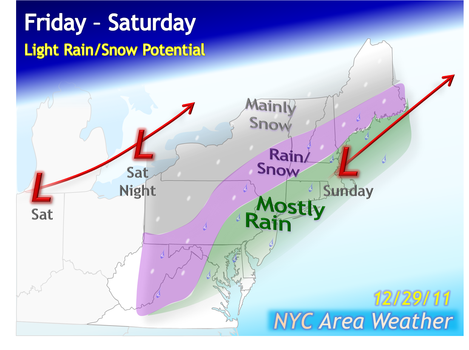
Dec 29, 2011: Strong Cold Next Week
With the trough coming in behind the rain and wind event on Tuesday, Wednesday brought mostly cloudy skies with high temperatures peaking early in the day in the lower 40s inland, mid to upper 40s in the immediate NYC area, and the upper 40s in Long Island/S CT. Colder temperatures were observed last night, dropping into the upper 10s to lower 20s across northern NJ and SE NY, lower 20s in southern CT, lower to mid 20s in Long Island, and the mid 20s in NYC.
With partly sunny skies today, temperatures will only reach the 30s across the area, but a clipper moving towards the Northeast will bring warmer air, with temperatures once again reaching the 50s between Friday and Sunday across most of the area. Although the pattern has not changed, signs of minor changes in the pattern will become more apparent next week as the strongest trough so far this winter will drop into the region towards the middle of next week, with high temperatures across most of the area likely to struggle to reach 20-25 degrees next Wednesday.
Today's Outlook:
Partly sunny skies are expected today, becoming mostly cloudy by the evening as clouds from a weak clipper near the Great Lakes move towards the area, although very little, if any precipitation is expected through tonight. High temperatures will be in the mid 30s inland and the mid to upper 30s across the rest of the area.
Friday - Sunday: Mild, Little Rain; Warmer Start To 2012
 The current cold temperatures will be pushed out tonight by an approaching storm from the west. This type of storm, categorized as an "Alberta Clipper" due to its origin near Alberta, Canada, typically dives southeast through the northern US before moving off the Mid Atlantic/NE coast, bringing snow showers in the Mid Atlantic and Northeast. With the current pattern, however, the clipper is unable to drop far south enough to produce snow for the area. The clipper currently located near the Great Lakes is producing widespread snow showers as far as Maryland, Virginia and southern Pennsylvania, although these snow showers are expected to dissipate due to drier air as the storm moves further east.
The current clipper will be absorbed by a second clipper coming in behind it, which will then move towards the Great Lakes on Friday. This clipper will push the cold out of the area, with mild temperatures peaking in the upper 40s to lower 50s across the area along with scattered showers. Temperatures tomorrow night will stay mild, only dropping into the mid 30s to lower 40s across the area, along with more scattered showers. The risk of showers will last through Saturday afternoon with mild temperatures again, peaking in the mid to upper 40s across most of the area. Briefly colder temperatures are expected overnight, with New Year's Eve at midnight expected to bring partly cloudy skies with temperatures near the upper 30s. The first day of the new year will start out even warmer, with temperatures reaching the lower to mid 50s across the area on Sunday along with partly sunny skies, but the surge of warmth will only be short lasting ahead of what will be the most significant cold spell of the winter so far.
Monday - Wednesday: Much Colder, Windy; Some Snow Showers?
With the new year comes the first opportunity for a true cold spell across the region. So far this winter, cold spells have been weak and transient, lasting for no more than one day at once before moving out. In fact, only three days so far this month have had below average temperatures in NYC, in sharp contrast to last December when the majority of the month was below to well below average. The pattern is not flipping to a cold and snowy one with this cold spell, as the NAO/AO remain positive with the polar vortex still stuck over Alaska, but the upcoming cold spell is a sign that the pattern is starting to slightly moderate, with the ridge in the southeastern US in place since early November weakening, almost completely dissipating in the medium range on the models.
 An intensifying low pressure will move through the Great Lakes region on Sunday night into Monday, with scattered showers moving into the area on Sunday night with the cold front. Behind this front, however, there is nothing to prevent the arctic air from central Canada from spilling south, and a much colder air mass will move into the region. Temperatures will first stay slightly above average on Monday, peaking in the upper 30s to mid 40s across the area along with partly cloudy skies. As temperatures aloft continue to drop, colder overnight lows are expected in the mid 10s to lower 20s across most of the area with mid 20s in NYC, and with significant lake effect snows possible in the Great Lakes region, the potential is there for a few of these snow showers to make it as far south/east as the NYC area, which I mentioned in the 5-day outlook with a risk of isolated snow showers across the area. Windy conditions are expected as well on Monday, gusting up to 30-40 mph across parts of the area.
The coldest temperatures are expected on Tuesday and Wednesday. With 850 mb temperatures still dropping throughout the day below -10 degrees celsius, much colder temperatures are expected on Tuesday with partly cloudy skies, possibly a few isolated snow showers, and temperatures steady through the early afternoon in the mid 20s inland and the upper 20s to lower 30s across the rest of the area, dropping by the mid to late afternoon. Windy conditions are expected throughout the day as well, keeping wind chills between the single digits and the teens. With clearing skies on Tuesday night as a high pressure moves in, much colder temperatures are expected, likely to drop into the single digits further north/west from NYC, especially focusing over SE NY and NW NJ, with lows in the mid 10s possible in NYC as well. Combined with the winds, wind chills could potentially drop into the single digits across a large part of the area. Mostly sunny skies are expected for Wednesday with very cold high temperatures, struggling to reach 20-25 degrees across the area, and in the colder case scenario may fail to pass 20 degrees in the northwestern parts of the area. Stay tuned for more information on this cold spell.
Longer Range: Warmth Potentially Returns
As previously mentioned, this strong cold spell is not an indication that the pattern has flipped to a cold and snowy one, as there is still no blocking near Greenland with the Alaskan polar vortex still present, two factors signaling that any cold is transient and will not stay for long. The cold will weaken on Thursday and Friday with high temperatures warming back up into the 30s again, although there is another shortwave expected to approach the region towards Friday. There is some uncertainty with how the models handle this, and there are two main potential scenarios at this time. The first scenario with less support is where the shortwave moves through with scattered precipitation followed by more cold. The second scenario with more support, however, is where the large ridge in the western US spreads further east as yet another trough drops into the western US, a set up supporting a potentially significant warm spell across the region with well above average temperatures potentially returning once again. This is still too far in the longer range to know which scenario will verify, although at least from the latest models, the warm spell scenario is looking more likely. Stay tuned for more information on the longer range.
With partly sunny skies today, temperatures will only reach the 30s across the area, but a clipper moving towards the Northeast will bring warmer air, with temperatures once again reaching the 50s between Friday and Sunday across most of the area. Although the pattern has not changed, signs of minor changes in the pattern will become more apparent next week as the strongest trough so far this winter will drop into the region towards the middle of next week, with high temperatures across most of the area likely to struggle to reach 20-25 degrees next Wednesday.
Today's Outlook:
Partly sunny skies are expected today, becoming mostly cloudy by the evening as clouds from a weak clipper near the Great Lakes move towards the area, although very little, if any precipitation is expected through tonight. High temperatures will be in the mid 30s inland and the mid to upper 30s across the rest of the area.
Friday - Sunday: Mild, Little Rain; Warmer Start To 2012
The current clipper will be absorbed by a second clipper coming in behind it, which will then move towards the Great Lakes on Friday. This clipper will push the cold out of the area, with mild temperatures peaking in the upper 40s to lower 50s across the area along with scattered showers. Temperatures tomorrow night will stay mild, only dropping into the mid 30s to lower 40s across the area, along with more scattered showers. The risk of showers will last through Saturday afternoon with mild temperatures again, peaking in the mid to upper 40s across most of the area. Briefly colder temperatures are expected overnight, with New Year's Eve at midnight expected to bring partly cloudy skies with temperatures near the upper 30s. The first day of the new year will start out even warmer, with temperatures reaching the lower to mid 50s across the area on Sunday along with partly sunny skies, but the surge of warmth will only be short lasting ahead of what will be the most significant cold spell of the winter so far.
Monday - Wednesday: Much Colder, Windy; Some Snow Showers?
With the new year comes the first opportunity for a true cold spell across the region. So far this winter, cold spells have been weak and transient, lasting for no more than one day at once before moving out. In fact, only three days so far this month have had below average temperatures in NYC, in sharp contrast to last December when the majority of the month was below to well below average. The pattern is not flipping to a cold and snowy one with this cold spell, as the NAO/AO remain positive with the polar vortex still stuck over Alaska, but the upcoming cold spell is a sign that the pattern is starting to slightly moderate, with the ridge in the southeastern US in place since early November weakening, almost completely dissipating in the medium range on the models.

The coldest temperatures are expected on Tuesday and Wednesday. With 850 mb temperatures still dropping throughout the day below -10 degrees celsius, much colder temperatures are expected on Tuesday with partly cloudy skies, possibly a few isolated snow showers, and temperatures steady through the early afternoon in the mid 20s inland and the upper 20s to lower 30s across the rest of the area, dropping by the mid to late afternoon. Windy conditions are expected throughout the day as well, keeping wind chills between the single digits and the teens. With clearing skies on Tuesday night as a high pressure moves in, much colder temperatures are expected, likely to drop into the single digits further north/west from NYC, especially focusing over SE NY and NW NJ, with lows in the mid 10s possible in NYC as well. Combined with the winds, wind chills could potentially drop into the single digits across a large part of the area. Mostly sunny skies are expected for Wednesday with very cold high temperatures, struggling to reach 20-25 degrees across the area, and in the colder case scenario may fail to pass 20 degrees in the northwestern parts of the area. Stay tuned for more information on this cold spell.
Longer Range: Warmth Potentially Returns
As previously mentioned, this strong cold spell is not an indication that the pattern has flipped to a cold and snowy one, as there is still no blocking near Greenland with the Alaskan polar vortex still present, two factors signaling that any cold is transient and will not stay for long. The cold will weaken on Thursday and Friday with high temperatures warming back up into the 30s again, although there is another shortwave expected to approach the region towards Friday. There is some uncertainty with how the models handle this, and there are two main potential scenarios at this time. The first scenario with less support is where the shortwave moves through with scattered precipitation followed by more cold. The second scenario with more support, however, is where the large ridge in the western US spreads further east as yet another trough drops into the western US, a set up supporting a potentially significant warm spell across the region with well above average temperatures potentially returning once again. This is still too far in the longer range to know which scenario will verify, although at least from the latest models, the warm spell scenario is looking more likely. Stay tuned for more information on the longer range.
Wednesday, December 28, 2011
Dec 28, 2011 Evening Update
Due to some problems, I was unable to post an update tonight. Instead of a full update tonight, I will post a full update including a discussion on the forecast and an updated 5-day forecast on Thursday morning, with a shorter update for Thursday evening. The update will discuss the main highlights of the forecast, including scattered showers for Friday/Saturday as well as the strong cold spell expected for next week, with temperatures on Wednesday night likely to drop below 10 degrees for the interior parts of the area with even New York City likely to see highs in the 20s on Thursday.
Reminder - The updated winter outlook will be posted on January 1st, with an update on the outlook through January and February.
***IMPORTANT NOTICE***
The blog has now moved to the following address:
www.nycareaweather.com
The old address of weatherinnyc.blogspot.com still works, although it will redirect you to the new address.
Please save the new address to your favorites.
Tuesday, December 27, 2011
Dec 27, 2011: Cold Returns Tomorrow
The squall line has moved through NYC, with places from NYC and further west drying up as the storm moves to the east. Strong wind gusts were observed across the area with the squall line, with wind gusts reaching 48 mph in LaGuardia and JFK so far. Reports of higher wind gusts over 50 mph are likely to come in likely in Long Island and southern CT within the next hour. Temperatures steadily warmed up ahead of the squall line and ended up slightly warmer than expected, with the high temperature peaking late this evening in the lower to mid 50s inland and the mid to upper 50s across the rest of the area.
Skies will clear tomorrow with much colder temperatures, especially for the overnight hours into Tuesday, along with gusty winds throughout the day on Wednesday. The return of colder temperatures will be brief as a clipper moves into the region, bringing light rain showers, possibly mixing with light snow north and west of NYC on Saturday, ending just in time for New Year's Eve. The start of the new year could perhaps bring new opportunities for storms, however, as there are more signs for a potentially stronger storm affecting the region around the start of January.
Tomorrow's Outlook:
A high pressure moving towards the region will bring clearing skies across the area. As a much colder air mass will move into the area throughout the day, temperatures will be steady in the morning to the early afternoon hours in the upper 30s inland and the lower 40s across the area, starting to drop for the rest of the afternoon hours into the 30s. A breezy west wind is expected, gusting up to 30-40 mph across the area.
Much colder temperatures are expected for tomorrow night as skies clear, winds diminish and radiational cooling takes place. Temperatures are expected to drop into the lower to mid 10s inland, mid 10s to lower 20s in the north/west suburbs of NYC and southern CT, upper 10s to mid 20s in Long Island, and the mid to upper 20s in NYC. The eastern parts of Long Island that typically see colder temperatures with radiational cooling are likely to drop into at least the mid 10s. With breezy winds especially in the evening, wind chills will fall below 20 degrees across the entire area.
Thursday - Sunday: Clipper Brings Light Rain/Snow For Fri/Sat
With the high pressure over the region, mostly sunny skies are expected again for Thursday with colder temperatures, peaking in the mid 30s inland and the mid to upper 30s across the rest of the area, reaching 40 degrees in parts of the immediate NYC area and Long Island. As a weak clipper moves towards the region from the Great Lakes, however, clouds will increase on Thursday night as isolated showers approach from the west. Most of the precipitation from the clipper will stay to the north of the area on Friday and Saturday, keeping the best chance for snow once again to the north of the area, across the Northeast, while temperatures aloft stay mostly above freezing across the area.
On Friday and Friday night, mostly cloudy skies are expected with high temperatures reaching the mid 40s across most of the area with mid to upper 40s in the immediate NYC area. Any precipitation that falls will most likely be in the form of rain in the immediate NYC area and Long Island, possibly mixing with snow showers in interior southern Connecticut and NW NJ/Orange County in NY. As colder temperatures move in, light snow showers may mix in as far southeast as the north/west suburbs of NYC on Saturday morning before the clipper moves out of the region, bringing high temperatures into the mid 40s to lower 50s on Saturday afternoon along with partly cloudy skies in time for New Year's Eve and temperatures in the mid 30s to start out the new year. Not so surprisingly, above average temperatures will continue into the first day of 2012, with high temperatures reaching the mid to upper 40s across the area, possibly reaching 50 degrees again in NYC.
Next Week: Storm And Cold Possible?
Differences with the models significantly increase by early next week. The models are in agreement with showing a low pressure moving towards the Great Lakes region on Monday, but significantly differ with details afterwards. The GFS model brings the low pressure through Maine before bringing a very strong cold air mass into the region, with high temperatures only near 20-25 degrees in NYC. The CMC brings a stronger cold front through, with the last frame of the 12z CMC, at Tuesday night, showing a developing coastal low with snow across parts of the area and more snow approaching from the south. The most interesting model of the day, however, was the ECMWF, showing a major snowstorm for the region with both of its runs today. The morning run of the ECM showed heavy rain for the area, but with heavy snow falling not too far west, from Virginia into Pennsylvania and New York. The 12z run showed another strong storm but further east, bringing a significant snowstorm for a large part of the NYC area.
Although the models are showing different solutions, most of the models do show more amplification in the set up across the US than what we have recently seen, with a stronger ridge in the western US and a stronger trough in the eastern US, perhaps the strongest trough the region has seen so far this winter. Although the pattern remains mostly unfavorable, transient features in the pattern such as a temporary western US ridge do show that the potential for a more significant storm, although still low, is in fact there. Although the GFS model may be correct with not showing a coastal low, it is most likely too strong with the intensity of the cold spell that it shows, and is expected to change its solution over the next 1-2 days. The ECM is most likely too amplified, showing a nearly ideal scenario needed to produce a snowstorm for the area, but while the storm may not be as strong as it shows, both the ECM and the CMC show that there is at least the potential for a storm to affect the area, although the timing, location and intensity remain uncertain. The GFS and CMC ensembles show no storm for Tuesday into Wednesday, however, and although less amplification should be expected with ensemble means this far out, the 12z ECM ensemble mean does not show any storm affecting the area on Wednesday, unlike the operational ECM run which shows the storm.
Although there is the potential for a more significant storm around early-mid next week, this potential is uncertain, and especially given the pattern in place, is still low at this time, although this is still subject to change. Regardless of whether a storm affects the region or not, however, a trough is likely to move into the region around early-mid week, bringing much colder temperatures, possibly the coldest the area has seen so far this winter if the trough ends up amplified as currently modeled. Stay tuned for more information on the longer range outlook throughout the next several days.
Dec 27, 2011 Storm Updates
Below, occasional updates will be posted on the rain and wind event currently affecting the area.
-----------------------------------------------------------
7:50 PM: Strong Winds Developing, Squall Line Approaches
 After a line of moderate rain moved through about an hour ago in NYC, locally heavy rain squalls are currently affecting places from NYC and further west with temperatures steadily rising into the mid 50s. A squall line is currently near western New Jersey, containing heavy rain, strong wind gusts, and some thunder. This line will move through the immediate NYC area between 8-9 PM, and the eastern parts of the area between 9-11 PM. Winds from now until the passage of the squall line will gust up to 35-45 mph in most of northern NJ/SE NY, 40-50 mph in NYC, and 45-55 mph in Long Island and southern Connecticut, with winds slightly calming down behind the front but with gusts up to 30 mph lasting through the overnight hours, intensifying during the day on Wednesday up to 40 mph.
------------------------------------------------------------
4:35 PM: Heavy Rain, Wind Approaching
 The storm moved into the area slightly earlier than expected, with rain already affecting parts of the area as early as 2 PM. With the storm moving in earlier than expected, it will also move out earlier than originally expected. Steady rain will continue to fall across the area over the next few hours with temperatures expected to slightly rise through the evening hours. A somewhat disorganized line of moderate to locally heavy rain, wind and some thunderstorms will affect the western parts of the area by at least 5-7 PM, affecting the immediate NYC area between 6-9 PM and the eastern parts of the area by 7-11 PM. During this time frame, winds will gust up to 40 mph in the central and eastern parts of the area, locally reaching 40-50 mph in parts of Long Island especially with any thunderstorms. The storms will end by 9-10 PM west of NYC and 10 PM-12 AM east of NYC, with breezy winds lasting through parts of the overnight hours.
Looking a bit ahead, temperatures will be steady in the upper 30s inland and the lower 40s across the rest of the area on Wednesday before dropping by the mid to late afternoon hours along with winds gusting up to 35-40 mph across most of the area, with much colder temperatures overnight dropping below 20 degrees for most areas north and west of NYC. Tonight's update will discuss the cold for the next two days in more details, as well as two clippers bringing scattered rain and snow showers for Friday and Saturday as well as a more significant cold and/or storm potential for next week.
Monday, December 26, 2011
Dec 26, 2011: Above Average Temperatures Continue
With a weak low pressure moving away from the region, today brought partly sunny skies across the area, with high temperatures reaching the mid 40s inland and the mid to upper 40s across the rest of the area. Exactly one year ago, the NYC area observed one of its strongest blizzards, with high winds, 20+ inches of snow in parts of the area, and blizzard conditions for several consecutive hours. This year, however, not only has the area not seen any significant snowfall during meteorological winter, excluding October, but the majority of the area has not seen any snow at all since late October. In fact, if New York City does not observe snow through 12/31, which is likely, this would end up as only the third year in the 140+ years of recorded history that Central Park has not seen any snow in December. The two other years this has happened, 1877 and 2006, ended up with well below average snowfall for the entire winter.
Temperatures will stay above average through Wednesday, with temperatures peaking tomorrow evening in the mid 40s inland and the lower to mid 50s across the rest of the area at the same time that heavy rain and thunderstorms move through the area, along with strong wind gusts up to 40-50 mph possible in parts of the area. Although the rain will mostly end by 12 AM Tuesday night, windy conditions will continue through Wednesday, gusting up to 40 mph at times, followed by colder temperatures for Wednesday night into Thursday. As with the other cold spells this winter, however, this will also be transient, and will quickly be replaced by above average temperatures in time for New Year's Eve along with scattered showers.
Tomorrow's Outlook: Rain, Thunderstorms, Wind
As a low pressure approaches from the southwest, cloud cover will increase, with cloudy skies expected by the afternoon along with temperatures peaking in the mid 40s inland and the upper 40s to lower 50s across the area. Temperatures are then expected to slightly drop by the late afternoon as showers start to fall across the area after 3-5 PM.
The low pressure has trended west of yesterday's forecast, and is now likely to track through central Pennsylvania into eastern New York, and is also weaker than previously expected, although the only noticeable change coming out of this trend is slightly weaker winds. Temperatures will remain steady in the western parts of the area in the mid 40s, while rising in the immediate NYC area by 10 PM into the upper 40s to lower 50s and Long Island/S CT into the lower to mid 50s. A line of heavy rain and thunderstorms will move through the area around the evening hours, especially between 7-10 PM west of NYC and 8-11 PM east of NYC. Strong wind gusts are possible in the central and eastern parts of the area, with gusts generally reaching the 30-40 mph range with some areas seeing gusts between 40-50 mph, especially in Long Island. The storm will then quickly move out of the area, with the rain ending west of NYC by 10 PM to 12 AM and east of NYC between 11 PM and 1 AM, although gusty winds will continue through the morning hours, gusting up to 30-40 mph.
Wednesday - Sunday: Cold Start, Warmer Ending
With a colder air mass moving into the region, temperatures on Wednesday will be steady in the upper 30s inland and the lower to possibly mid 40s across the rest of the area. Gusty winds will continue throughout the day as well, with gusts up to 40 mph, possibly slightly higher in Long Island. As a high pressure moves into the region, skies will clear with diminishing winds as temperatures steadily drop into the mid 10s inland and the upper 10s to mid 20s across the rest of the area with warmer temperatures in NYC. Mostly sunny skies are expected for Thursday with high temperatures in the mid to upper 30s across most of the area.
The cold temperatures will be short lasting once again as a weak low pressure will move towards the Great Lakes region, pushing out the cold air mass in place. As a result, warmer temperatures will return for Friday, peaking in the lower to mid 40s inland and the mid 40s across the rest of the area. Scattered precipitation is possible on Friday, and although the precipitation could fall as snow showers in the interior parts of the area, temperatures will likely be too warm to support snow in the rest of the area. Scattered showers will continue through Friday night and Saturday morning, potentially mixing with snow showers in the north/western parts of the area, with temperatures again peaking in the lower to mid 40s across most of the area on Saturday. Partly cloudy skies are likely for New Year's Eve with temperatures potentially near the mid 30s, with partly to mostly cloudy skies lasting through Sunday along with temperatures reaching the mid 40s across most of the area.
Sunday, December 25, 2011
Dec 25, 2011: Rain, Thunderstorms, Wind Return
Notes: A Wind Alert is in effect for the entire area for Tuesday night into Wednesday.
In addition, I opened a poll earlier today, found in the right side of the blog below the regional radar, for the most extreme weather event of the year. To find more information on each event, visit the "Storm Summary" page or this afternoon's post, which included a brief summary of each event. The poll will close on January 4th.
--------------------------------------------------------
With a weak low pressure approaching the region, today brought partly to mostly cloudy skies across the area while widespread snow showers affected the rest of the Northeast. High temperatures were above average, yet normal for the pattern we're currently in, peaking in the lower 40s inland and in the mid to upper 40s across the rest of the area.
Another brief trough will bring colder temperatures for tonight and tomorrow, although an approaching storm will bring more rain for Tuesday night, along with strong winds, temperatures back above 50 degrees and thunderstorms. The rain will end by late Tuesday night, although the wind will stick around through Wednesday, followed by some of the coldest temperatures so far this winter for Wednesday night into Thursday.
Tomorrow's Outlook:
As a colder air mass will move into the region, slightly cooler yet still slightly warmer than average temperatures are expected for tomorrow, peaking in the lower to mid 40s inland and the mid 40s across the rest of the area. Gusty winds are expected as well, with gusts up to 35 mph. Colder temperatures are expected for tomorrow night, dropping into the lower to mid 20s inland and the upper 20s to mid 30s across the rest of the area.
Tuesday - Wednesday: Rain, Thunderstorms, Strong Winds Return
The last storm to bring unseasonable conditions for December into the area was on last Wednesday, when temperatures passed 60 degrees and a squall line brought widespread thunderstorms and some severe weather for parts of the area. Although temperatures will not be as warm, the storm that will affect the region on Tuesday night will bring unseasonable conditions for December once again.
 The low pressure will develop over the southern states, moving towards Virginia by Tuesday afternoon. As the storm will be in the process of phasing with the northern stream, it will become more amplified while intensifying and moving NNE, ending up near eastern New York on Tuesday night and west of Maine on Wednesday, although the northern half of the track may end up west of what I am currently expecting. There are currently two main model solutions, with the further east NAM taking the storm just inland, the CMC/GFS taking it over NJ/eastern PA and towards Maine, with the ECM and UKMET further west. Considering the scenario and the latest model trends, I am siding with the further west ECM/UKMET for this storm. When the storm first moves into the region, there will not be much cold air associated with it, but more cold air will enter the storm as it moves out of the region. As a result, the moderate snows will be focused from northern PA into parts of western and northern NY with several inches of wet snow possible. Further south, areas well north/west of I-95 will see a mix of rain and snow, ending up as rain to snow west of the storm track and a mix to rain east of the storm track. Rain is expected to fall across the area.
The storm will not last for a long time across the area, and is expected to end west of NYC between 11 PM and 2 AM and east of NYC between 1-4 AM, with scattered showers possible afterwards. Overall, by the time that the storm ends, at least 1/2 to 1 inch of rain is expected across the area, with amounts locally up to 1.5 inch. Behind the storm, moderate wind gusts are expected across the entire area, gusting up to 30-40 mph at times. Wednesday will bring temperatures steady in the upper 30s to lower 40s inland and the lower to mid 40s across the rest of the area with the winds lasting throughout the day, gusting up to 30-40 mph. Stay tuned for more information on this storm and its impact in the NYC area.
Thursday - Next Weekend: Cold Start, Warmer Weekend
Behind the storm, a stronger trough will move into the region, bringing some of the coldest temperatures so far this winter. With the winds lasing through Wednesday evening, cold wind chills are likely across the area. As a high pressure moves in, the winds will calm down with clearing skies overnight, which combined with the cold air mass in place, will bring temperatures down into the mid 10s inland, upper 10s to mid 20s in the north/west suburbs of NYC, southern CT, and Long Island, and upper 20s in NYC. Mostly sunny skies are expected for Thursday with highs in the lower to mid 30s inland and the mid 30s across the rest of the area, potentially reaching the upper 30s in parts of the immediate NYC area.
As a weak low pressure moves towards the Great Lakes, warmer temperatures will return, reaching the mid 40s across most of the area on Friday and the mid to upper 40s on Saturday with the risk of a few showers on Friday night. For New Year's Eve, partly cloudy skies are likely in Times Square with temperatures likely in the mid 30s. Slightly cooler temperatures will return for Sunday but still in the lower to mid 40s across most of the area.
Looking into the longer range, although the pattern is still overall unfavorable, there are more noticeable changes showing up in the long range models, most notably with more stratospheric warming taking place, which is a factor needed for a colder and snowier pattern to develop. Through the first week of January, above average temperatures are likely to continue with a few storm potentials, one of them possibly around January 2-3, and while the Northeast would still be favored over the NYC area to see snow, it is not out of the question that at least one of the storms in the first 10 days of January brings the second snow event of the winter to parts of the NYC area. There is still uncertainty with the changes showing up in the long range, and it is possible that the pattern stays unfavorable for sustained cold and snow through the rest of January, but if the latest signals are correct, the mid January time frame may be when cold as well as snow/mixed precipitation become more frequent across the region, including the NYC area. Stay tuned for more information on the longer range, especially with the updated winter outlook that will be issued on January 1st.
Dec 25, 2011 Afternoon Update
1:45 PM: Thunderstorms, Strong Winds For Tuesday Night
As my updates over the last two nights mentioned, an intensifying storm tracking over the area will bring heavy rain and gusty winds to the area. With the latest models trending west and stronger, however, I am adjusting my forecast storm track from New Jersey to eastern Pennsylvania, possibly slightly further west. With this change, I introduced a risk of thunderstorms for the central and eastern parts of the area with the updated 5-Day Forecast, with temperatures rising overnight, peaking towards midnight in the mid to upper 40s inland, lower to mid 50s in the immediate NYC area and the mid 50s in Long Island/S CT.
Stronger wind gusts are a concern with this storm as well. A strong low level jet will move over the area on Tuesday night, which combined with the rain and thunderstorms will bring the potential for strong wind gusts. Exactly how strong the winds end up is still uncertain, but for now, the potential is there for 35-45 mph gusts in the immediate NYC area and 40-50 mph gusts in Long Island and southern CT, potentially exceeding 50 mph in parts of Long Island especially under any convection. For now, I issued a Wind Alert for the area, which could be upgraded to a High Wind Watch for parts of Long Island.
Tonight's update will discuss the heavy rain, thunderstorm and wind potential in more detail for the area along with a scenario map showing my expectation for the storm, as well as cold temperatures expected for Wednesday night into Thursday.
----------------------------------------------------------
Poll: What Was The Most Extreme Event Of 2011?
At the end of last year, I opened a poll for the most extreme event of 2010. The winning event was the December 26-27, 2010 blizzard with 20 votes. For this year, I opened a new poll, which can be found in the right side of the blog below the regional radar. More information on each event except for the cold/heat spells and the mid August rain event can be found in the Storm Summary page, with a brief highlight of each event below:
January 11-12 Blizzard: A strong coastal low brought moderate snow up to 10 inches west of NYC, with 15-30 inches across most of Long Island and southern Connecticut with blizzard conditions and thundersnow.
January 21-24 Cold: Very cold temperatures affected the area, with widespread sub-zero lows across the arae with single digit lows in NYC, as well as daytime highs below 20 degrees.
January 26-27 Blizzard: Another nor'easter affected the area, bringing very heavy snowfall rates focusing on NYC, southern CT and Long Island, with some places seeing near or over 4 inches per hour. Snow totals were between 10-20" across the majority of the area.
February 1-2 Ice Storm: A large ice storm affected the area, with widespread freezing rain amounts near 1/2 inch across the area.
March 6-11 Flooding: Two separate storms affected the area, each bringing 2-4 or more inches north and west of NYC with lighter amounts further southeast resulting in widespread flooding, especially in northern NJ and SE NY.
July 21-24 Extreme Heat: A record breaking heat wave affected the area, with widespread heat indices near or above 110 degrees, with Newark observing a record high temperatures of 108 degrees.
July 29-Aug 1 Large Hail: Severe thunderstorms affected parts of the area, bringing an EF-1 tornado to Goshen, NY on 7/29, and large hail in parts of NYC on August 1.
Hurricane Irene: Record rain amounts affected the area with 6-11 inches, along with wind gusts between 40-60 mph resulting in power outages for days.
Oct 29-30 Snowstorm: A record early snowstorm affected the area, with record breaking October snowfall across almost the entire area. Central Park saw 2.9 inches, with amounts over a foot of snow in the interior parts of the area, near 19 inches in West Passaic county.
Saturday, December 24, 2011
Dec 24, 2011: Rainy Tuesday, Cold Wednesday
With a colder air mass briefly moving into the region today, temperatures were colder than the last few days, with mostly sunny skies and high temperatures reaching the mid 30s inland and the mid to upper 30s across the rest of the area. Warmer temperatures will return for Christmas with partly sunny skies, sticking around through Monday before the next storm affects the area on Tuesday night with rain and wind, potentially gusting up to 40 mph in parts of the area. The storm will bring in colder temperatures behind it once again, with briefly below average temperatures likely again for Thursday.
Tomorrow's Outlook: Mostly Cloudy, Dry
A trough moving into the region will bring partly sunny skies for Christmas with slightly warmer temperatures, reaching the lower to mid 40s inland and the mid to upper 40s across the rest of the area. Mostly cloudy skies are expected for the overnight hours with the potential for a few isolated rain or snow showers, especially north of NYC.
Monday - Wednesday: Becoming Stormy, Windy
Mostly sunny skies are expected to return for Monday with slightly cooler high temperatures. As a storm approaches the region from the southwest, cloud cover will increase on Tuesday with temperatures rising into the lower to mid 40s across the area and a few isolated showers developing late. There is uncertainty with the exact track of the low pressure, although at this time it is expected to track over New Jersey or NYC, bringing moderate to locally heavy rain for Tuesday night with temperatures reaching a peak towards midnight in the lower 40s inland, mid to upper 40s in most of the immediate NYC area, and the upper 40s to lower 50s in Long Island and southern Connecticut. If the storm tracks over New Jersey, temperatures in parts of the immediate NYC area will reach the lower 50s as well. Along with the rain, gusty winds will develop especially as the storm exits, with wind gusts expected to reach the 30 to 40 mph range across most of the area, potentially slightly higher in Long Island. Partly cloudy skies will return for Wednesday with highs reaching the upper 30s to mid 40s and wind gusts reaching the 30-40 mph range again. Stay tuned for more information on the outlook for Tuesday and Wednesday.
Thursday - Next Weekend: Colder Start, Then Warming Up
A colder air mass will return into the area on Wednesday night, and although there is some uncertainty with the temperatures, the potential is there for lows to drop again into the 10s in interior areas north and west of NYC, making Wednesday night one of the coldest nights so far this winter. High temperatures on Thursday will likely reach the mid to upper 30s across most of the area, with temperatures warming up again for Friday.
Uncertainty returns for the weekend, as the GFS and the CMC show a clipper potentially reaching the region with scattered snow showers, even for parts of the area, while the ECM shows showers with mild temperatures, reaching the 50s once again. All models are not handling the set up completely correct considering the time range, although given the pattern, I would lean towards the slightly warmer solutions at this time, with any potential precipitation over the weekend more likely to fall as snow in the interior Northeast than the NYC area, although in the colder case scenario some snow showers for parts of the area aren't impossible. Stay tuned for more information on the longer range, including the outlook for New Year's Eve and New Year's Day.
Friday, December 23, 2011
Dec 23, 2011: Rain Returns Tuesday Night
After a fast moving wave of low pressure brought moderate rain to the area last night, with the southern parts of the area exceeding 1 inch in some places, today brought mostly cloudy skies and dry conditions, with high temperatures reaching the mid to upper 40s inland and the upper 40s to lower 50s across the rest of the area. With a trough moving into the region, tomorrow will bring cold temperatures into the area again, although temperatures will warm up again for Christmas with mostly cloudy skies. The models changed their solutions for Sunday night, so while a coastal storm will not develop near the Mid Atlantic coast as some runs yesterday suggested, the storm potential has now been moved to Tuesday night into Wednesday, with widespread rain expected once again.
Weekend Outlook:
Mostly sunny skies are expected across the area on Saturday with colder temperatures. The intensity of the cold air mass has been slightly underestimated by the models, and as a result, colder temperatures are expected for tomorrow than first thought, with highs reaching the lower to mid 30s inland and the mid to upper 30s across the rest of the area. Tomorrow night will bring colder temperatures, dropping into the upper 10s to lower 20s inland, lower to upper 20s across the rest of the area and upper 20s to lower 30s in NYC.
Partly sunny skies are expected for Christmas as a weak disturbance approaches the region, with more clouds developing by the evening hours. High temperatures will be in the lower to mid 40s across the area. Temperatures will drop into the upper 20s to mid 30s across most of the area overnight with mostly cloudy skies as the disturbance to the north of the area brings widespread snow showers into the Northeast. Although a few isolated rain or snow showers cannot be ruled out across the area, only isolated precipitation at most is expected in the NYC area, if any precipitation does fall.
Monday - Wednesday: Warmer, More Rain
Mostly sunny skies will return for Monday with slightly cooler temperatures expected. By Tuesday, however, a storm is now expected to approach the area. Some models yesterday showed an unlikely scenario of a coastal low developing close to the coast as a shortwave near Texas phased with the northern stream. The models late last night backed away from this scenario, however, with the shortwave sticking around in Texas through Monday before phasing with the northern stream on Tuesday. With the set up still unfavorable for any snowstorm in the area, this scenario will likely result in a storm tracking to the west of the area on Tuesday night, with moderate rain expected to fall on Tuesday night before likely clearing the area by Wednesday morning. There is some uncertainty on the exact track of the storm, and for now, I am expecting the track to end up near or slightly to the west of the model guidance, bringing another possible scenario where temperatures rise into the evening into the upper 40s or potentially the lower 50s in the warmer case scenario in parts of the area before dropping later on in the overnight hours. Wednesday will then bring drier conditions with high temperatures dropping back into the upper 30s to mid 40s across the area. Stay tuned for more information on the outlook for the middle of next week.
Late Next Week - Next Weekend:
Colder temperatures are likely to last through Thursday with mostly sunny skies, although another potential storm will approach the region on Friday, bringing warmer temperatures with more cloud cover likely. The outlook for next weekend is more uncertain as the models are having issues handling the set up in the US starting from Thursday, although the latest models agree on the potential for some unsettled weather in parts of the weekend into early next week. Stay tuned for more information on the longer range.
Thursday, December 22, 2011
Dec 22, 2011: Light Rain/Snow For Christmas?
Behind last night's cold front, which brought brief yet heavy thunderstorms with strong wind gusts across the area, today brought dry conditions with temperatures not so surprisingly ending up well above average once again, reaching the 60 degree mark for the 4th time so far this month in parts of the area. Temperatures peaked in the lower to mid 50s inland, upper 50s to lower 60s in the immediate NYC area, and in the upper 50s across Long Island and southern Connecticut. Temperatures will cool down back to near average this weekend with a few rain or snow showers possible, although temperatures will warm up once again by the start of next week.
 Short Term Outlook: Heavy rain is already affecting parts of New Jersey, and will spread across the rest of the area by 12 AM. The storm is quickly moving through the region, and after several hours of heavy rain between at least 12 to 4 AM, the rain is likely to clear the area by 6 AM, with dry conditions and mostly cloudy skies by the mid to late morning hours on Friday. Storm totals will end up between 1/2 and 1.25 inch across the area.
Tomorrow's Outlook:
After the storm will leave the area, clearing skies are expected by the afternoon hours tomorrow as a colder air mass moves into the region. Slightly colder yet still noticeably warmer than average temperatures are expected tomorrow, with highs reaching the mid to upper 40s inland and the upper 40s to lower 50s across the rest of the area.
Weekend Outlook: Cold Saturday, Rain/Snow Showers On Sunday?
Saturday will bring mostly sunny skies to the area as a stronger yet brief cold air mass moves into the area, with high temperatures dropping into the mid to upper 30s inland and the upper 30s to lower 40s across the area. A trough will approach the region for Sunday, but more uncertainty increases with how the models handle the set up. The GFS shows the cutoff low in the southern US phasing with the northern stream, resulting in a coastal storm developing, but because the northern stream is dominant, the storm develops too far north and too far east to result in any significant precipitation for the region. The NAM, however, does not show the phasing that the GFS has, as the cutoff low is stuck around Texas while the trough moves into the area. Although scattered rain and snow showers are possible across the area especially towards Sunday night, anything more than light precipitation is unlikely to fall. Otherwise, mostly cloudy skies are expected for Christmas with high temperatures reaching the lower to mid 40s across the area. Stay tuned for more information on the outlook for the weekend.
Next Week And Beyond: Warmer Start To Week
Mostly sunny skies will return to the area on Monday with temperatures staying relatively chilly but still warmer than average, peaking in the lower to mid 40s across most of the area. A warmer air mass will briefly return to the region on Tuesday, with temperatures expected to warm up into the mid to upper 40s across the area. This warm up will only be brief, however, and partly sunny skies are expected for Wednesday and possibly into Thursday with highs likely dropping back into the lower to mid 40s.
Looking at the longer range again, through the start of January there are still no indications that the pattern is flipping around to a cold and snowy one, especially with the development of a polar vortex near Alaska in the medium range, which often indicates warmer conditions across the region. Through the middle of January, there could be a few minor snow potentials for the area, but little snow is likely to fall from now until early January with temperatures staying above average. Unlike my medium range pattern outlooks from a while ago, however, more indications are starting to appear for potential stratospheric warming towards the longer range. It will take time for any stratospheric warming to break the pattern down, as it has been firmly established in place for the last few months, but if the pattern does break and evolve into a colder and snowier one, the more likely time frame for this to happen still appears to be by the second half of January and into February. For now, there are no large changes in my thoughts for the long range, although more updates will be posted as January gets closer, including an updated winter outlook on January 1st.
Dec 22, 2011 Evening Update: Rain Approaches
8:20 PM: Heavy Rain Soon To Start

Tonight's update will be posted by 10 PM, with more information on the weekend outlook, the outlook for next week, and a couple of new developments on the pattern through January.
Wednesday, December 21, 2011
Dec 21, 2011: Mild Pattern Continues Through End Of Month
As this evening's update mentioned, conditions across the area can be described as fall-like, if not almost summer-like. Temperatures surged into the lower 60s in parts of the area, unusual especially for overnight hours of December, and a squall line moved through the area, producing widespread brief heavy downpours, thunderstorms and gusty winds. Temperatures will drop later tonight into the 40s before rising again into the mid 50s, and although temperatures for Friday and the weekend will be colder, mostly above average temperatures are still likely to continue.
Tomorrow's Outlook:
Mostly to partly sunny skies are expected for Thursday morning, increasing towards the evening hours. Temperatures will be mild again, reaching the lower to mid 50s inland and the mid 50s across the area, potentially reaching the upper 50s near and southwest of NYC.
Temperatures will steadily drop on Thursday night as a weak yet moist wave of low pressure moves through the area, bringing widespread moderate to heavy rain between 12-2 AM to about 7-9 AM on Friday. The northern parts of the area, especially towards Orange, Putnam counties, and interior southern CT will mix with some snow, but the best potential for snow will stay in interior southern/central New England. By the time that the storm ends on Friday morning, at least 1/2 to 1 inch of rain is expected across the area, with amounts locally above 1 inch possible in parts of the immediate NYC area.
Friday - Weekend: Colder, But Not Significantly Below Average
Last weekend ended up bringing temperatures much colder than expected, especially with the models significantly underestimating the intensity of the cold air mass. Although temperatures will be colder for the weekend, temperatures as cold as those of last weekend are not expected considering that the air mass is not as cold. Friday will bring clearing skies with high temperatures reaching the mid to upper 40s inland and the upper 40s across the rest of the area, potentially reaching 50 degrees near NYC.
Saturday will continue with partly cloudy skies and high temperatures reaching the lower 40s inland and the lower to mid 40s across the rest of the area. As a trough approaches from the west, however, mostly cloudy skies are expected for Christmas with chilly yet warmer than average high temperatures, reaching the lower to mid 40s again across most of the area. The potential is there for a storm on Christmas, although not high; the models a few days ago showed a larger storm before backing away yesterday, and although the set up on the models indicates that the potential may be there for some precipitation, more significant changes are needed with the set up to reintroduce the possibility of a larger storm. For now, I am expecting mostly cloudy skies with the potential for scattered rain or snow showers across the area, and although there is a small probability that more precipitation affects at least parts of the area, the probability of this is is very low at this time, and it is much more likely that only isolated precipitation affects the area. Stay tuned for more information on this time frame.
Longer Range: Temperatures on Monday will slightly cool down, with temperatures similar to those of Saturday expected. The trough will once again be pushed out of the area, with temperatures once again climbing into the mid to potentially upper 40s on Tuesday. Colder temperatures are possible for the second half of next week. More information will be posted on the longer range as details become clearer.
Dec 21, 2011 Evening: Summer in December?
10:00 PM: Heavy Rain, Thunderstorms, 60+ Degrees For Late December
 The official start of winter is only hours away, yet the scenario the area is currently seeing can almost be described as summer-like. Although temperatures are nowhere near as warm as they would be in the summer, temperatures are currently in the lower 60s in the immediate NYC area. Although my brief update from Monday did expect this rise in temperatures, tonight's temperatures were not expected to pass 60 degrees, and temperatures will likely continue to slightly rise over the next few hours, and might even get close to 65 degrees in the immediate NYC area.
In addition to the unusually mild temperatures, an approaching cold front is bringing yet another scenario very unusual for late December: a squall line of thunderstorms. Although this is not producing any severe weather, heavy thunderstorms with brief downpours are intensifying and moving east. This line is currently located near West Passaic in NJ and eastern Orange county in NY, and will reach the immediate NYC area towards 10:15 to 10:30 PM, and Long Island and southern Connecticut towards 11 PM. This line will be capable of producing heavy rain and gusty winds, with temperatures then likely to drop behind this line.
A full length text discussion will be posted later tonight, discussing the heavy rain for Thursday night and the forecast for Christmas weekend.
Tuesday, December 20, 2011
Dec 20, 2011 Afternoon
Monday, December 19, 2011
Dec 19, 2011 Brief Update
Note: The 5-Day Forecast page was updated tonight for the immediate NYC area only. A full update will be posted on Tuesday afternoon, with a 5-day forecast for the entire area and a detailed discussion on the upcoming stormy pattern. A brief overview of the forecast has been posted below.
-------------------------------------------------------
Tuesday - Thursday: Unusually Mild, Rainy
Temperatures on Tuesday will peak in the lower to potentially mid 40s across the area. Wednesday will bring occasional showers, mainly in the afternoon and evening, with temperatures gradually rising into the lower to mid 50s. Temperatures will peak in the lower to mid 50s across the area, possibly reaching the upper 50s close to NYC, on Wednesday night, before the cold front moves through with cooler temperatures by the morning. Thursday will bring mostly sunny skies with mild temperatures, reaching the mid 50s across most of the area with upper 50s possible near NYC and parts of Long Island.
- Thursday Night: A wave of low pressure will quickly move through the area, bringing light to moderate rain across the area, potentially mixing with light snow in the far northwestern parts of the area. The storm will end on Friday morning, with partly cloudy skies for Friday afternoon with temperatures reaching the mid to upper 40s.
- Weekend Outlook: Lots Of Uncertainty
The forecast models are showing conflicting indications for the weekend, with some supporting no precipitation, others showing a storm for Saturday night and another one for Monday, and the ECM shows a storm for Sunday. The models are having a lot of issues with handling this time frame, so for now, I kept mostly cloudy skies and a chance for showers, potentially in the form of light snow for parts of the area for Sunday into Monday, but at this time, it appears that the best chance of precipitation could end up sometime between Saturday night and Monday. Stay tuned for more information for the weekend outlook with Tuesday's discussion.
Saturday, December 17, 2011
Dec 17, 2011: Much Colder Temperatures For Sunday
As a trough moved into the region today, mostly cloudy skies were observed with colder high temperatures, reaching the upper 30s to lower 40s inland and the lower to mid 40s across the rest of the area. Scattered flurries were even observed in parts of the area. As a colder air mass moves in, much colder temperatures are expected tonight, with the coldest temperatures so far this winter possible, with much colder high temperatures expected for tomorrow. This cool down will be brief, with warmer temperatures returning next week along with more rain for the mid week, mixing with light snow in the interior parts of the area at the start of the storm, before colder temperatures return again towards the end of next week into the weekend.
Tomorrow's Outlook:
The model guidance has been underestimating the intensity of the cold air mass for the last few days, as the models have been gradually trending colder for tomorrow's highs, a trend which is still continued with tonight's 00z NAM run, which interestingly keeps almost the entire area below freezing for high temperatures, with temperatures failing to reach 30 degrees north and west of NYC. The NAM and GFS typically have a slight cold bias when it comes to high temperatures during cold spells, so while widespread below freezing high temperatures are not expected at this time, Sunday will end up much colder than previously expected.
With mostly to partly cloudy skies tonight, temperatures will steadily drop across the area, reaching the mid to upper 10s inland, upper 10s to mid 20s across NE NJ, SE NY and southern CT, lower to upper 20s in Long Island, and upper 20s to lower 30s in NYC. With mostly to partly sunny skies on Sunday, much colder high temperatures are expected, reaching the upper 20s inland and the lower to mid 30s across the rest of the area.
Monday - Thursday: Warmer, Rain; Some Interior Snow
With the trough quickly moving out, Monday will bring warmer temperatures once again, reaching the lower to mid 40s inland and the mid 40s across the rest of the area, potentially reaching the upper 40s near and southwest of NYC, along with mostly sunny skies. Clouds will increase on Monday night as a cold front approaches the area, stalling nearby on Tuesday while bringing mostly cloudy skies with the risk of isolated showers, potentially mixing with light flurries towards NW NJ/Orange County. Temperatures will be colder as well, peaking in the upper 30s to lower 40s inland and the lower to mid 40s across the rest of the area.
There is no high pressure to hold the cold air mass in place as the next storm approaches for Wednesday and Wednesday night, and a warm air mass will move into the area to bring rain for the main part of the storm. Despite the warmer air mass moving in, the potential is there for precipitation to move into the area on Tuesday night while parts of the cold air mass are still left. Although the air mass is not very cold, it will be cold enough to bring the potential for a rain/snow mix in the interior parts of the area, especially in northern NJ, SE NY and southern Connecticut, although very little, if any accumulations are expected from any wintry mix. Wednesday will bring warmer temperatures, reaching the mid 40s inland and the upper 40s across the rest of the area, along with occasional showers. These showers will continue through Wednesday night with temperatures staying steady at first before slightly dropping. Drier conditions will return for Thursday afternoon and evening with high temperatures ending up similar to, if not slightly warmer than those of Wednesday.
Longer Range: Searching For Snow
The pattern recently has been unusually mild compared to what is typically observed during December; since December 1, the entire East Coast is covered with warmer than average temperatures. NYC has been approximately 5 degrees warmer than average, with parts of the Northeast seeing much higher departures. This is a result of the current pattern which is unfavorable for cold and snow in the East, with a +NAO, +AO, a lack of blocking near Greenland, and a cold stratosphere. There continue to be no signs of any significant stratospheric warming event throughout the long range, and while there will be minor changes with the pattern from time to time, at least through early to potentially mid January, no pattern flip is expected where the East sees a more consistently colder and snowier pattern.
Although the pattern is unfavorable for snowstorms, it does not mean that snow is impossible in the region, especially if the timing and locations of storms are supportive. As I mentioned with my update last night, although snow is not impossible in the NYC area, anything more than light snow is unlikely under this pattern. There have been times when snowstorm happened with unfavorable patterns, such as late February and late March this year, but many parts of the set up have to end up in the right places for such a scenario to happen.
Since the models changed some parts of the Wednesday storm, parts of the outlook have changed for the late week into next weekend. Increased clouds are likely on Friday with the potential for some showers, before colder temperatures potentially return for the weekend. Yesterday, it was mentioned that there could be a storm potential over the weekend, but due to the changes in the timing, this potential was moved to Friday into early Saturday. Looking forward into the time frame after Christmas, however, the first potential for a snow event could be possible for the area. The pattern is still unfavorable, and a significant snowstorm is very unlikely, but if any low pressure in the time frame ends up in the right location with supportive timing, a snow event could be possible for parts of the region, potentially including the area, although the Northeast would still have a higher probability than the Mid Atlantic of seeing a more significant snowstorm. This potential is still highly uncertain, and especially given the unfavorable pattern, it is possible that this potential may fail to materialize and the area sees a mild rain again. Stay tuned for more information on the longer range.
Friday, December 16, 2011
Dec 16, 2011: Colder Weekend, Warmer Next Week
As a colder air mass started to move into the region today, colder temperatures were observed, peaking during the day in the mid 40s inland and the upper 40s to lower 50s across the rest of the area, although the 24-hour high temperatures were observed in the early morning hours, as temperatures overnight were steady in the 50s across the area, temperatures unusually warm for overnight hours during December - for instance, in Central Park, temperatures tonight were steady between 55 and 59 degrees. The average overnight temperature is 32 degrees, more than 20 degrees colder than tonight's temperature, and the average high temperature is 43 degrees.
With the cold air mass moving in, temperatures will briefly drop back to near to even slightly below average temperatures, reaching the upper 30s to lower 40s tomorrow and the mid to upper 30s on Sunday. These colder temperatures will only be brief, however, as temperatures warm back up into the 40s next week and potentially into the 50s on Wednesday. Another storm will affect the area in the middle of next week, but in addition to the rain, the potential is there for some light snow to fall in the interior parts of the area.
Weekend Outlook:
Saturday will bring partly cloudy skies across the area along with a NNW wind expected. A colder air mass will continue to move into the region, with 850 mb temperatures ending up near -10 degrees celsius, the coldest air mass to move into the region so far this winter. With the colder air mass, colder temperatures are expected across the area, reaching the upper 30s to lower 40s inland, lower 40s in most of the immediate NYC area, and lower to mid 40s in Long Island and southern Connecticut.
As a weak disturbance approaches the Great Lakes, mostly cloudy skies are expected overnight. The models over the last day underestimated the cold on Saturday night, and it now appears that Saturday night will bring the coldest temperatures, dropping into the upper 10s to lower 20s inland and the lower to upper 20s across the rest of the area except for NYC, where temperatures are expected to reach the upper 20s to lower 30s. Partly cloudy skies are expected for Sunday with slightly below average temperatures, peaking in the mid 30s inland and the mid to upper 30s across the rest of the area.
Monday - Wednesday: Warmer, Rain Returns; Some Interior Snow?
The trough in place over the weekend will quickly be pushed out on Monday, with a warmer air mass returning. As a result, warmer temperatures are expected, reaching the mid 40s inland and the mid to upper 40s across the rest of the area along with mostly sunny skies. The high pressure on Monday will quickly move out as a cold front moves towards the area on Tuesday, however, and clouds will increase on Monday night with mostly cloudy skies expected for Tuesday along with slightly cooler temperatures.
A low pressure in the central US will move towards the region, bringing more rain into the area. With some precipitation moving into the area when there is still some cold air, a mix of light rain and snow is possible in the northern and western parts of the area, although accumulations, if any, will be limited to the northernmost parts of the area. As a warmer air mass moves into the region with the low pressure, any frozen precipitation will change over to rain later into Tuesday night as steadier rain develops and temperatures slightly warm up towards the morning. Occasional showers are expected on Wednesday, and although exact temperatures are still uncertain, the potential is there for temperatures to reach the lower 50s in the immediate NYC area. Stay tuned for more information on the Tuesday-Wednesday storm.
Thursday - Next Weekend: Drier End To Week, Weekend Storm Possible
Drier conditions are expected to return into the region behind the mid week storm for Thursday and the first half of Friday, with temperatures slightly cooling down, back into the 40s. Towards the second half of Friday and into the weekend, however, uncertainty increases again as a potential storm approaches the region. The only consistency with the models is that the potential is there for a storm in this time frame; the location, timing and intensity of the storm continue to vary from run to run. During this time frame, the pattern remains the same as it has been so far, with a ridge still in place in the Southeast with a positive NAO/AO and no blocking. With the pattern in place, a nor'easter bringing a snowstorm to the I-95 corridor in the Mid Atlantic is very unlikely. There are some slight improvements in the overall set up in the US, and while this storm does not have a high or even a medium probability at this time of bringing any notable frozen precipitation event to the area, it does appear to have a slightly better chance of bringing some sort of frozen precipitation to parts of the area than other recent storms. While some frozen precipitation may be possible in the northern Mid Atlantic, including the area, places further north into the Northeast would be more likely to see a snowstorm than the NYC area. A snowstorm in parts of the NYC area is not completely impossible, but considering that the most important variables for a Mid Atlantic snowstorm including blocking, -NAO and strong western US ridging are missing, it will be difficult for such a scenario to happen. There is still \uncertainty on whether there will be a storm this weekend, as the timing on the models is inconsistent as well, with some showing a storm this weekend and others showing one later into the week, so while it's not certain that a storm will affect the region over the weekend, the possibility is there. Stay tuned for more information on the weekend outlook.
Brief Long Range Outlook: Looking at the pattern beyond next weekend, there is still no evidence of any large scale pattern change in the 15 day range, and likely beyond the 15-day range as well. The stratosphere remains very cold, with the cold air trapped in Canada along with a positive NAO/AO. Without the -NAO and the blocking, the brief troughs that move into the region are transient, quickly moving out with more ridging returning afterwards. One of the main parts needed to change the pattern to bring more winter-like conditions into the region includes a SSW, or a significant stratospheric warming event. A warmer stratosphere will help to displace the cold air from Canada, bringing more cold and snow into the region. During the previous two winters, height anomalies at 500mb were higher than average over Greenland and parts of Canada, displacing the colder air into the US. With the current pattern, however, there are negative height anomalies over Greenland and Canada, with warmer than average temperatures over the eastern US. Some models show slight warming in the stratosphere through the long range, but there is no SSW event apparent in the 15-day range and likely beyond. Considering that the pattern right now has been locked into place for months and is still solidly in place, it will take time for this pattern to begin falling apart. My expectations have not changed since my winter outlook, as I continue to expect the current pattern to hold in place with a few minor changes at times until at least the middle of January. There could be a few snow events until then, but otherwise above average temperatures are expected to continue, with the best risk of snowstorms staying in the Northeast. Towards the second half of the winter, the potential is there for more cold and snow, although it does not appear that any strong cold and heavy snow pattern will set up like the last two winters. More information will be posted on the long range on occasions throughout the rest of the month, with an updated winter outlook to be posted on January 1st.
Thursday, December 15, 2011
Dec 15, 2011: Colder Weekend Ahead
A dry cold front affected the region today, bringing widespread cloudy skies and scattered showers. The immediate NYC area ended up staying dry today without rain, although very small details such as exact locations where it will not rain are difficult to forecast more than a few hours in advance. Temperatures ended up slightly warmer than expected, peaking in the mid 50s inland, upper 50s in the immediate NYC area, and in the mid 50s in Long Island and southern Connecticut. Today's high temperatures once again ended up well above average, ending up 16 degrees warmer than average in Central Park and making today Central Park's 9th day so far this month above 50 degrees. In comparison, even December 2006, which was a mild and snowless month, did not have this many days above 50 degrees through 12/15.
Colder temperatures will gradually return, but will be slow to do so, with mild temperatures staying around again tomorrow, reaching the lower 50s in parts of the immediate NYC area and Long Island. A stronger yet transient trough will move through the region this weekend, bringing high temperatures back into the mid 30s to lower 40s with partly cloudy skies. Not so surprisingly, temperatures will warm up once again by next week, reaching the upper 40s in NYC on Monday, followed by more rain for the middle of next week with temperatures potentially reaching the 50s once again.
Tomorrow's Outlook:
 As a colder air mass begins to move in, slightly cooler yet warmer than average temperatures are expected tomorrow across the area along with mostly to partly sunny skies. Temperatures tomorrow will rise into the mid to upper 40s inland and the upper 40s across the rest of the area, with lower 50s expected in parts of the immediate NYC area and Long Island/S CT. Breezy northwest winds are expected.
Weekend Outlook: Colder Temperatures Briefly Return
The aforementioned trough will move into the region on Saturday, bringing colder temperatures for the weekend. A wave of low pressure will move through the southern Mid Atlantic on Friday night, bringing partly to mostly cloudy skies across the area with scattered showers getting as far north as Cape May, NJ and Washington DC. With cold temperatures aloft, these showers could mix with a little non-accumulating snow in parts of central/northern Virginia. Partly cloudy skies will continue throughout the day on Saturday, with high temperatures reaching the upper 30s to lower 40s inland and the lower 40s in the immediate NYC area, Long Island, and southern Connecticut.
As a coastal low pressure will develop well offshore, a weak disturbance will move through the Great Lakes into the Northeast on Saturday night, bringing widespread snow showers into the western Northeast. The best risk of flurries/snow showers will be focused over the eastern Mid Atlantic, specifically towards SE Pennsylvania and potentially parts of Maryland/Delaware, as well as eastern Massachusetts. Although no widespread snow showers will fall in the NYC area, there is a slight potential for isolated flurries west of NYC. Temperatures will cool down again on Sunday with partly cloudy skies, reaching the mid to upper 30s inland and the upper 30s across the rest of the area, potentially slightly passing 40 degrees in parts of the immediate NYC area.
Next Week's Outlook: Warmer Once Again, Rain Returns By Mid-Week
 As a low pressure well to the north of the region pushes out the trough, a ridge will once again begin to build into the eastern US, with mostly sunny skies and warmer temperatures returning for Monday, reaching the mid to upper 40s across the area. Although this ridge will not be as strong as some of the other ridges in the East earlier this month and in November, the area will still end up under the warm air mass, with above to well above average temperatures lasting through next week. The low pressure to the north will bring its cold front just to the north of the area, with mostly cloudy skies and isolated showers expected for Tuesday with slightly cooler temperatures expected.
A storm will approach the area towards Tuesday night into Wednesday, but the exact location and timing of the storm are still uncertain as the forecast models are still having issues with handling the set up for this storm. The ECM model until recently attempted to take the storm well to the north of the area, but recent runs have adjusted towards the further south GFS model, tracking the storm through the Northeast. Regardless of the track, rain is expected to affect the area sometime between Tuesday night and Wednesday night, and depending on the location of the storm, temperatures may warm up again into the lower to potentially mid 50s in parts of the area, especially if the storm does track through the Northeast as currently modeled. Temperatures will cool back down into the 40s for late next week with dry conditions likely to return. Friday night's update will include more information on the outlook for next week, as well as a brief discussion on the longer range outlook and what the area can expect through the rest of December.
Colder temperatures will gradually return, but will be slow to do so, with mild temperatures staying around again tomorrow, reaching the lower 50s in parts of the immediate NYC area and Long Island. A stronger yet transient trough will move through the region this weekend, bringing high temperatures back into the mid 30s to lower 40s with partly cloudy skies. Not so surprisingly, temperatures will warm up once again by next week, reaching the upper 40s in NYC on Monday, followed by more rain for the middle of next week with temperatures potentially reaching the 50s once again.
Tomorrow's Outlook:

Weekend Outlook: Colder Temperatures Briefly Return
The aforementioned trough will move into the region on Saturday, bringing colder temperatures for the weekend. A wave of low pressure will move through the southern Mid Atlantic on Friday night, bringing partly to mostly cloudy skies across the area with scattered showers getting as far north as Cape May, NJ and Washington DC. With cold temperatures aloft, these showers could mix with a little non-accumulating snow in parts of central/northern Virginia. Partly cloudy skies will continue throughout the day on Saturday, with high temperatures reaching the upper 30s to lower 40s inland and the lower 40s in the immediate NYC area, Long Island, and southern Connecticut.
As a coastal low pressure will develop well offshore, a weak disturbance will move through the Great Lakes into the Northeast on Saturday night, bringing widespread snow showers into the western Northeast. The best risk of flurries/snow showers will be focused over the eastern Mid Atlantic, specifically towards SE Pennsylvania and potentially parts of Maryland/Delaware, as well as eastern Massachusetts. Although no widespread snow showers will fall in the NYC area, there is a slight potential for isolated flurries west of NYC. Temperatures will cool down again on Sunday with partly cloudy skies, reaching the mid to upper 30s inland and the upper 30s across the rest of the area, potentially slightly passing 40 degrees in parts of the immediate NYC area.
Next Week's Outlook: Warmer Once Again, Rain Returns By Mid-Week

A storm will approach the area towards Tuesday night into Wednesday, but the exact location and timing of the storm are still uncertain as the forecast models are still having issues with handling the set up for this storm. The ECM model until recently attempted to take the storm well to the north of the area, but recent runs have adjusted towards the further south GFS model, tracking the storm through the Northeast. Regardless of the track, rain is expected to affect the area sometime between Tuesday night and Wednesday night, and depending on the location of the storm, temperatures may warm up again into the lower to potentially mid 50s in parts of the area, especially if the storm does track through the Northeast as currently modeled. Temperatures will cool back down into the 40s for late next week with dry conditions likely to return. Friday night's update will include more information on the outlook for next week, as well as a brief discussion on the longer range outlook and what the area can expect through the rest of December.
Wednesday, December 14, 2011
Dec 14, 2011: Warm Late Week, Cold Weekend
Mostly sunny skies were observed across the area today, with less cloud cover than expected. Temepratures were noticeably warmer than expected as well, reaching the upper 40s to lower 50s inland, lower to mid 50s in the immediate NYC area, and the upper 40s to lower 50s in Long Island and southern Connecticut. As a cold front approaches the region tomorrow, more cloud cover is expected with scattered showers along with warmer temperatures, reaching the mid to upper 50s in the immediate NYC area, before slightly cooling down on Saturday but staying above average by as much as 8-12 degrees. Colder temperatures will return for this weekend, with isolated snow showers possible on Sunday, although temperatures will once again warm up next week with more rain on the way.
Tomorrow's Outlook:
Cloudy skies are expected for tomorrow, with scattered showers expected especially after 1-3 PM across most of the area. These scattered showers will continue through the evening and early overnight hours, with less than 1/4 inch of rain expected. Temperatures will be warmer, reaching the lower 50s inland, mid 50s in the immediate NYC area, and the lower to mid 50s in Long Island and southern Connecticut. Upper 50s are possible near and southwest of NYC, bringing tomorrow's temperatures as much as 10-15 degrees above average.
Friday - Monday: Dry, Isolated Snow Showers Possible On Sunday
The cold front will move past the area on Friday, with mostly to partly sunny skies expected, but as there isn't any strong push of cold air immediately behind the front, temperatures will stay mild, peaking in the mid to upper 40s inland and the upper 40s to lower 50s across the rest of the area, once again getting to nearly 10 degrees above average near and east of NYC.
A wave of low pressure is expected to affect the Mid Atlantic on Friday night into Saturday with light rain and some snow showers, and while no precipitation is expected in the area, mostly clear to partly cloudy skies will continue overnight into Saturday, with colder high temperatures expected for Saturday, reaching the upper 30s to lower 40s inland and the lower to mid 40s across the rest of the area. These temperatures will be some the coldest high temperatures so far this month, but they are still near to slightly warmer than average. A weak disturbance will move through the region on Saturday night into Sunday with partly to mostly cloudy skies expected, with scattered snow showers likely in the Northeast. Although uncertain, the potential is there for some of these scattered snow showers to make it into the northern and western parts of the area. High temperatures will be colder on Sunday, reaching the mid to upper 30s inland and the upper 30s to lower 40s across the rest of the area, potentially slightly warmer in parts of the immediate NYC area.
Warmer temperatures aloft will return once again by the early week as the trough exits, with temperatures warming up into the mid 40s inland and the mid to upper 40s across the rest of the area. Dry conditions are expected for Monday with partly sunny skies.
Next Week: Rain Returns; Warmer Than Average Again
There is more uncertainty for the outlook for next week as the models are having issues with handling an approaching system, although there will be a storm approaching the region, and rain is likely to affect the area again sometime between Tuesday afternoon and Thursday. A few models, most notably the GFS, have been showing the potential for front end frozen precipitation before changing over to rain, and although especially for interior areas, some frozen precipitation cannot be ruled out if the storm ends up far south enough with enough cold air initially in place, this storm is expected to bring mostly, if not plain rain across the area. Temperatures are uncertain due to the location of the storm, but are likely to end up above average. Stay tuned for more information on the outlook for next week.
Tuesday, December 13, 2011
Dec 13, 2011: Mild End To Week
Last night once again brought widespread cold temperatures to the area as expected, with temperatures dropping into the mid to upper 10s inland and the lower to mid 20s across most of the area except for parts of Long Island and NYC which saw warmer temperatures. With mostly sunny skies observed, temperatures were warmer today during the afternoon, reaching the mid to upper 40s inland and upper 40s across the rest of the area, although parts of Long Island reached the lower 50s. Slightly colder temperatures are expected tomorrow, although temperatures will warm up on Thursday ahead of the cold front, which will bring scattered showers later in the day followed by colder temperatures, with the weekend once again bringing highs into the mid 30s to lower 40s across most of the area.
Tomorrow's Outlook:
After a slightly warmer night, with temperatures for Wednesday morning slightly warmer than those of this morning but still cold, partly cloudy skies are expected on Wednesday, becoming mostly cloudy by the evening hours. Slightly cooler high temperatures are expected with a light and variable winds, with temperatures reaching the mid 40s inland and the mid to upper 40s across the rest of the area.
Wednesday Night - Friday: Warmer, Some Rain
A low pressure will move into the Great Lakes region on Wednesday night and Thursday, bringing front end precipitation into the region on Wednesday night. Scattered showers are expected across the area with most places seeing less than a tenth of an inch, although further north into Upstate New York and interior Connecticut, and potentially in parts of Sussex and Orange counties, the precipitation may start out as freezing rain before changing over to rain as the cold air mass is quickly pushed out. As a result, temperatures overnight will be steady in the mid 30s inland and in southern CT, upper 30s to lower 40s in the immediate suburbs of NYC and Long Island, and lower 40s in NYC. Temperatures are expected to slightly rise by the morning hours.
Cloudy skies will continue throughout the day on Thursday with a few breaks in the cloud cover possible early in the day. Temperatures will warm up into the lower to mid 50s across the area, and upper 50s are possible near and southwest of NYC. A weakening line of rain associated with the cold front will approach from the west, with scattered showers developing west of NYC between 3-4 PM and east of NYC between 4-6 PM. These scattered showers will continue through at least 12-2 AM, when any leftover showers will clear the area as cloud cover starts to clear with dropping temperatures. Temperatures will stay steady during most of the overnight hours in the mid 40s to lower 50s across most of the area, dropping towards Friday morning into the upper 30s to lower 40s inland, lower to mid 40s in the immediate NYC area and southern Connecticut, and the mid 40s in Long Island. Clearing skies are expected on Friday with slightly cooler high temperatures, reaching the mid to upper 40s inland and the upper 40s across the rest of the area, with parts of the immediate NYC area and Long Island passing 50 degrees.
Weekend Outlook: Colder, Scattered Interior Flurries?
Mostly to partly sunny skies will continue on Saturday as a much colder air mass moves into the region, bringing high temperatures into the upper 30s to lower 40s across most of the area. Partly cloudy skies are expected on Saturday night with low temperatures again dropping into the 20s across most of the area. A weak disturbance will approach the region on Sunday, bringing widespread snow showers across the Northeast, and while no heavy precipitation will fall out of this, the potential may be there for scattered flurries to affect the interior parts of the area, especially north and northwest of NYC. Temperatures on Sunday will be cold again, reaching the upper 30s to lower 40s across the area.
Early-Mid Next Week:
More sunshine is expected for Monday as a high pressure briefly returns, with temperatures warming up into the lower to mid 40s across most of the area. The dry conditions won't last for long, as a more organized system will reach the region towards the middle of next week. Although the location and timing of the storm are still uncertain, rain is likely to affect the area again towards the middle of next week. Stay tuned for more information on next week's outlook.
Subscribe to:
Posts (Atom)