
With partly sunny skies today, temperatures will only reach the 30s across the area, but a clipper moving towards the Northeast will bring warmer air, with temperatures once again reaching the 50s between Friday and Sunday across most of the area. Although the pattern has not changed, signs of minor changes in the pattern will become more apparent next week as the strongest trough so far this winter will drop into the region towards the middle of next week, with high temperatures across most of the area likely to struggle to reach 20-25 degrees next Wednesday.
Today's Outlook:
Partly sunny skies are expected today, becoming mostly cloudy by the evening as clouds from a weak clipper near the Great Lakes move towards the area, although very little, if any precipitation is expected through tonight. High temperatures will be in the mid 30s inland and the mid to upper 30s across the rest of the area.
Friday - Sunday: Mild, Little Rain; Warmer Start To 2012
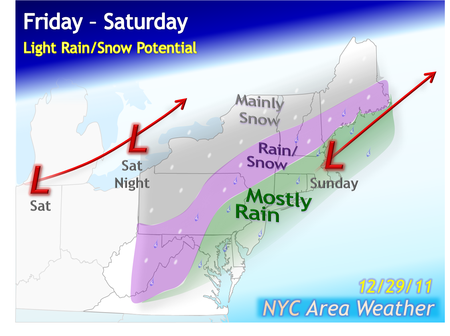
The current clipper will be absorbed by a second clipper coming in behind it, which will then move towards the Great Lakes on Friday. This clipper will push the cold out of the area, with mild temperatures peaking in the upper 40s to lower 50s across the area along with scattered showers. Temperatures tomorrow night will stay mild, only dropping into the mid 30s to lower 40s across the area, along with more scattered showers. The risk of showers will last through Saturday afternoon with mild temperatures again, peaking in the mid to upper 40s across most of the area. Briefly colder temperatures are expected overnight, with New Year's Eve at midnight expected to bring partly cloudy skies with temperatures near the upper 30s. The first day of the new year will start out even warmer, with temperatures reaching the lower to mid 50s across the area on Sunday along with partly sunny skies, but the surge of warmth will only be short lasting ahead of what will be the most significant cold spell of the winter so far.
Monday - Wednesday: Much Colder, Windy; Some Snow Showers?
With the new year comes the first opportunity for a true cold spell across the region. So far this winter, cold spells have been weak and transient, lasting for no more than one day at once before moving out. In fact, only three days so far this month have had below average temperatures in NYC, in sharp contrast to last December when the majority of the month was below to well below average. The pattern is not flipping to a cold and snowy one with this cold spell, as the NAO/AO remain positive with the polar vortex still stuck over Alaska, but the upcoming cold spell is a sign that the pattern is starting to slightly moderate, with the ridge in the southeastern US in place since early November weakening, almost completely dissipating in the medium range on the models.

The coldest temperatures are expected on Tuesday and Wednesday. With 850 mb temperatures still dropping throughout the day below -10 degrees celsius, much colder temperatures are expected on Tuesday with partly cloudy skies, possibly a few isolated snow showers, and temperatures steady through the early afternoon in the mid 20s inland and the upper 20s to lower 30s across the rest of the area, dropping by the mid to late afternoon. Windy conditions are expected throughout the day as well, keeping wind chills between the single digits and the teens. With clearing skies on Tuesday night as a high pressure moves in, much colder temperatures are expected, likely to drop into the single digits further north/west from NYC, especially focusing over SE NY and NW NJ, with lows in the mid 10s possible in NYC as well. Combined with the winds, wind chills could potentially drop into the single digits across a large part of the area. Mostly sunny skies are expected for Wednesday with very cold high temperatures, struggling to reach 20-25 degrees across the area, and in the colder case scenario may fail to pass 20 degrees in the northwestern parts of the area. Stay tuned for more information on this cold spell.
Longer Range: Warmth Potentially Returns
As previously mentioned, this strong cold spell is not an indication that the pattern has flipped to a cold and snowy one, as there is still no blocking near Greenland with the Alaskan polar vortex still present, two factors signaling that any cold is transient and will not stay for long. The cold will weaken on Thursday and Friday with high temperatures warming back up into the 30s again, although there is another shortwave expected to approach the region towards Friday. There is some uncertainty with how the models handle this, and there are two main potential scenarios at this time. The first scenario with less support is where the shortwave moves through with scattered precipitation followed by more cold. The second scenario with more support, however, is where the large ridge in the western US spreads further east as yet another trough drops into the western US, a set up supporting a potentially significant warm spell across the region with well above average temperatures potentially returning once again. This is still too far in the longer range to know which scenario will verify, although at least from the latest models, the warm spell scenario is looking more likely. Stay tuned for more information on the longer range.
No comments:
Post a Comment
Appropriate and subject relevant comments are welcome. Comments that are non-weather related or contain arguments with no legitimate reasoning to back up their claims are not tolerated and will be moderated and deleted.