Sunday, August 5 Observations:
Evening storms affected the area as a line of strong to severe thunderstorms moved through eastern PA and into New Jersey. The line affected NW NJ and SE NY with heavy rain and strong winds, although storms especially focused over east central NJ extending north towards NYC, as well as SW CT, with wind damage and power outages observed with the stronger storms. The line was weaker over parts of NE NJ and northwestern Long Island, where lighter rain amounts and weaker storms were observed, with rain totals near or less than 1/4 inch.
Tonight: Storms, Some Strong
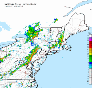
.gif) The regional radar as of 4:40 PM posted to the left shows a line of strong to severe thunderstorms over eastern Pennsylvania, moving towards NJ and the area. The line is expected to make it into the western half of the area within the next 1-2 hours, producing strong winds and localized flash flooding with rain above 1-2" in some areas. Afterwards, the line may slightly weaken as it moves into NYC and the eastern parts of the area, but will still be capable of producing localized heavy rain and flash flooding. Scattered storms are expected to continue into the early-mid overnight hours before ending by the early morning.
The regional radar as of 4:40 PM posted to the left shows a line of strong to severe thunderstorms over eastern Pennsylvania, moving towards NJ and the area. The line is expected to make it into the western half of the area within the next 1-2 hours, producing strong winds and localized flash flooding with rain above 1-2" in some areas. Afterwards, the line may slightly weaken as it moves into NYC and the eastern parts of the area, but will still be capable of producing localized heavy rain and flash flooding. Scattered storms are expected to continue into the early-mid overnight hours before ending by the early morning.Forecast Overview:
Drier conditions will return into the region with partly sunny skies on Monday and mostly sunny for Tuesday and Wednesday. Temperatures will remain warm, in the mid to upper 80s across most of the area, slightly cooler further east. A cutoff low pressure will move into the Great Lakes and the western Northeast on Friday, with scattered storms possible for Thursday and widespread thunderstorms, possibly heavy and/or strong, expected for Friday. Drier conditions are likely especially towards the second half of next weekend and into early next week with temperatures likely peaking in the upper 70s to mid 80s range.


Sir, Yesterday, New York had a Severe T'storm Warning Update by a Small bow echo has moved out the area, i saw couple of lightning and i heard few thunder.
ReplyDelete